Polonuevo night lights from space
Night Light of Polonuevo (Atlántico) from space (Colombia) Src. Average luminocity for 10x10km area is 12.1963% and for 50x50km: 17.0009%.
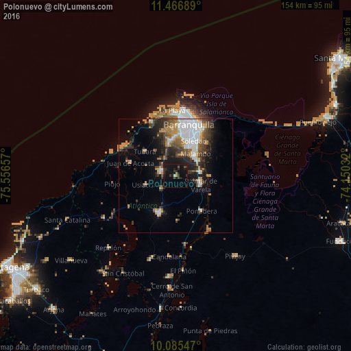
Analysis of Polonuevo night lights 2016
Square area 10x10 km:
 0%
0%90-99
0.41%80-89
0.41%70-79
0.21%60-69
1.45%50-59
1.65%40-49
1.65%30-39
4.55%20-29
4.96%10-19
23.97%0-9
60.74%Square area 50x50 km:
4.17%90-99
2.18%80-89
0.92%70-79
2.64%60-69
2.35%50-59
1.67%40-49
2.59%30-39
3.45%20-29
3.91%10-19
7.44%0-9
68.69%Clear (daylight) street map image can be seen on geolist.org.
Map coordinates:
11° 28' 0.8" North, 75° 33' 23.7" West
10° 46' 37.1" North, 74° 51' 12.4" West
10° 5' 7.7" North, 74° 9' 1.2" West
Some cities around Polonuevo sort by population:
• Malambo
12.6 km =7.8 mi,  43°
43°
• Baranoa
7.1 km =4.4 mi,  285°
285°
• Palmar de Varela
11.5 km =7.1 mi,  110°
110°
• Santo Tomás
11 km =6.8 mi,  101°
101°
• Sabanagrande
10.3 km =6.4 mi,  81°
81°
• Galapa
13.8 km =8.6 mi,  345°
345°
• Sitionuevo
14.5 km =9 mi,  89°
89°
• Usiacurí
13.9 km =8.6 mi,  254°
254°
3671950 (p: 11,727)
Sources (retrieved 2019-11-25):
» Earth at Night: Flat Maps 2012, 2016