Santuario night lights from space
Night Light of Santuario (Antioquia) from space (Colombia) Src. Average luminocity for 10x10km area is 13.2645% and for 50x50km: 12.796%.
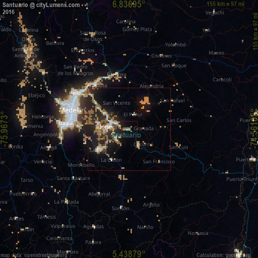
Analysis of Santuario night lights 2016
Square area 10x10 km:
 0.62%
0.62%90-99
0.21%80-89
0.62%70-79
2.69%60-69
2.48%50-59
5.17%40-49
0%30-39
0.83%20-29
0.83%10-19
19.63%0-9
66.94%Square area 50x50 km:
0.94%90-99
1.23%80-89
0.84%70-79
2.51%60-69
2.82%50-59
4%40-49
0.09%30-39
0.86%20-29
5.68%10-19
9.35%0-9
71.67%Clear (daylight) street map image can be seen on geolist.org.
Map coordinates:
6° 50' 13" North, 75° 58' 2.3" West
6° 8' 18" North, 75° 15' 51" West
5° 26' 19.6" North, 74° 33' 39.8" West
Some cities around Santuario sort by population:
• Rionegro
12.3 km =7.6 mi,  278°
278°
• Marinilla
8.9 km =5.5 mi,  296°
296°
• Carmen de Viboral
10 km =6.2 mi,  231°
231°
• La Unión
21.2 km =13.2 mi,  210°
210°
• Granada
8.7 km =5.4 mi,  86°
86°
• Guatapé
15.4 km =9.6 mi,  46°
46°
• Cocorná
12.5 km =7.8 mi,  135°
135°
• San Vicente
18.1 km =11.2 mi,  334°
334°
3668323 (p: 17,722)
Sources (retrieved 2019-11-25):
» Earth at Night: Flat Maps 2012, 2016