Santa Rosa de Osos night lights from space
Night Light of Santa Rosa de Osos (Antioquia) from space (Colombia) Src. Average luminocity for 10x10km area is 8.0801% and for 50x50km: 2.6274%.
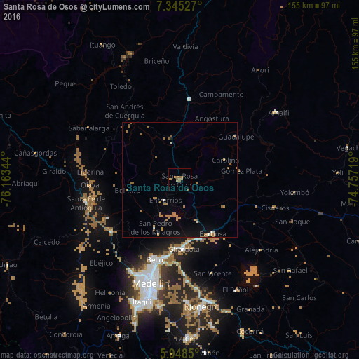
Analysis of Santa Rosa de Osos night lights 2016
Square area 10x10 km:
 0%
0%90-99
0.87%80-89
0%70-79
2.6%60-69
3.25%50-59
3.68%40-49
0%30-39
0%20-29
0%10-19
0%0-9
89.61%Square area 50x50 km:
0.11%90-99
0.13%80-89
0.03%70-79
0.88%60-69
1%50-59
0.46%40-49
0.03%30-39
0.03%20-29
0.07%10-19
1.04%0-9
96.21%Clear (daylight) street map image can be seen on geolist.org.
Map coordinates:
7° 20' 43" North, 76° 9' 48.4" West
6° 38' 50.6" North, 75° 27' 37.1" West
5° 56' 54.6" North, 74° 45' 25.9" West
Some cities around Santa Rosa de Osos sort by population:
• Bello
36.1 km =22.4 mi,  197°
197°
• Copacabana
33.9 km =21.1 mi,  189°
189°
• Yarumal
35.4 km =22 mi,  7°
7°
• Barbosa
27.3 km =17 mi,  148°
148°
• Guarne
40.8 km =25.4 mi,  177°
177°
• Donmatías
19.4 km =12.1 mi,  158°
158°
• San Pedro
23.3 km =14.5 mi,  207°
207°
• San Vicente
42.6 km =26.5 mi, 160°
3668451 (p: 10,191)
Sources (retrieved 2019-11-25):
» Earth at Night: Flat Maps 2012, 2016