San Pedro night lights from space
Night Light of San Pedro (Antioquia) from space (Colombia) Src. Average luminocity for 10x10km area is 5.8009% and for 50x50km: 15.0049%.
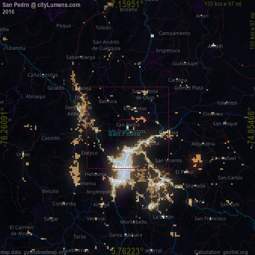
Analysis of San Pedro night lights 2016
Square area 10x10 km:
 0.65%
0.65%90-99
0.22%80-89
0%70-79
3.46%60-69
0%50-59
0%40-49
0.87%30-39
0%20-29
0%10-19
0%0-9
94.81%Square area 50x50 km:
3.05%90-99
2.47%80-89
0.84%70-79
1.96%60-69
2.75%50-59
2.31%40-49
0.49%30-39
1.59%20-29
3.67%10-19
10.13%0-9
70.73%Clear (daylight) street map image can be seen on geolist.org.
Map coordinates:
7° 9' 34.2" North, 76° 15' 39.3" West
6° 27' 40.9" North, 75° 33' 28" West
5° 45' 44" North, 74° 51' 16.8" West
Some cities around San Pedro sort by population:
• Medellín
23.3 km =14.5 mi,  181°
181°
• Bello
13.8 km =8.6 mi, 180°
• Itagüí
31.1 km =19.3 mi,  188°
188°
• Copacabana
13.9 km =8.6 mi,  157°
157°
• Barbosa
25.1 km =15.6 mi,  95°
95°
• Guarne
23.7 km =14.7 mi,  147°
147°
• Santa Rosa de Osos
23.3 km =14.5 mi,  27°
27°
• Donmatías
18.2 km =11.3 mi,  81°
81°
3669138 (p: 8,801)
Sources (retrieved 2019-11-25):
» Earth at Night: Flat Maps 2012, 2016