Cáqueza night lights from space
Night Light of Cáqueza (Cundinamarca) from space (Colombia) Src. Average luminocity for 10x10km area is 1.9587% and for 50x50km: 8.8734%.
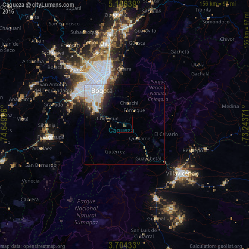
Analysis of Cáqueza night lights 2016
Square area 10x10 km:
 0%
0%90-99
0%80-89
0%70-79
0%60-69
0.41%50-59
1.24%40-49
1.65%30-39
0%20-29
0%10-19
0%0-9
96.69%Square area 50x50 km:
4.29%90-99
1.39%80-89
0.47%70-79
0.56%60-69
0.69%50-59
0.71%40-49
0.63%30-39
0.93%20-29
1.45%10-19
2.51%0-9
86.37%Clear (daylight) street map image can be seen on geolist.org.
Map coordinates:
5° 6' 23" North, 74° 38' 59.9" West
4° 24' 20.5" North, 73° 56' 48.6" West
3° 42' 15.6" North, 73° 14' 37.4" West
Some cities around Cáqueza sort by population:
• Bogotá
27.2 km =16.9 mi,  326°
326°
• Soacha
35.6 km =22.1 mi,  302°
302°
• Funza
45.4 km =28.2 mi,  319°
319°
• Mosquera
45.8 km =28.5 mi, 316°
• Sibaté
36 km =22.4 mi,  285°
285°
• La Calera
35.1 km =21.8 mi,  355°
355°
• Restrepo
45.8 km =28.5 mi,  110°
110°
• Fómeque
10.7 km =6.6 mi,  30°
30°
3687476 (p: 7,958)
Sources (retrieved 2019-11-25):
» Earth at Night: Flat Maps 2012, 2016