Mosquera night lights from space
Night Light of Mosquera (Cundinamarca) from space (Colombia) Src. Average luminocity for 10x10km area is 61.8471% and for 50x50km: 39.1143%.

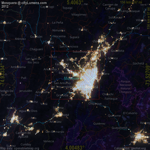
Analysis of Mosquera night lights 2016
Square area 10x10 km:
 14.26%
90-99
13.02%80-89
6.61%70-79
5.58%60-69
8.06%50-59
9.92%40-49
15.7%30-39
11.98%20-29
13.02%10-19
1.86%0-9
0%Square area 50x50 km:
13.98%90-99
6.29%80-89
2.57%70-79
4%60-69
4.12%50-59
4.82%40-49
5.2%30-39
5.5%20-29
7.05%10-19
11.46%0-9
35.01%Clear (daylight) street map image can be seen on geolist.org.
Map coordinates:
5° 24' 22.7" North, 74° 56' 0" West
4° 42' 21.3" North, 74° 13' 48.8" West
4° 0' 17.4" North, 73° 31' 37.5" West
Some cities around Mosquera sort by population:
• Bogotá
19.6 km =12.2 mi,  123°
123°
• Soacha
14.1 km =8.8 mi,  173°
173°
• Facatativá
18.3 km =11.4 mi,  311°
311°
• Funza
2.3 km =1.4 mi,  60°
60°
• Madrid
4.8 km =3 mi, 308°
• Sibaté
24.1 km =15 mi,  187°
187°
• Cota
18.6 km =11.6 mi,  51°
51°
• El Rosal
16.7 km =10.4 mi,  348°
348°
3674292 (p: 27,005)
Sources (retrieved 2019-11-25):
» Earth at Night: Flat Maps 2012, 2016