La Calera night lights from space
Night Light of La Calera (Cundinamarca) from space (Colombia) Src. Average luminocity for 10x10km area is 23.9298% and for 50x50km: 31.174%.
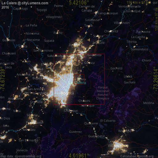
Analysis of La Calera night lights 2016
Square area 10x10 km:
 0%
0%90-99
0.41%80-89
0.41%70-79
1.03%60-69
2.27%50-59
10.12%40-49
8.47%30-39
13.43%20-29
16.12%10-19
11.57%0-9
36.16%Square area 50x50 km:
12.33%90-99
4.91%80-89
1.9%70-79
3.26%60-69
3.41%50-59
4.15%40-49
3.48%30-39
3.97%20-29
5.34%10-19
6.44%0-9
50.81%Clear (daylight) street map image can be seen on geolist.org.
Map coordinates:
5° 25' 15.8" North, 74° 40' 20.6" West
4° 43' 14.5" North, 73° 58' 9.3" West
4° 1' 10.6" North, 73° 15' 58.1" West
Some cities around La Calera sort by population:
• Bogotá
17.5 km =10.9 mi,  225°
225°
• Chía
18.3 km =11.4 mi,  327°
327°
• Funza
26.9 km =16.7 mi,  268°
268°
• Cajicá
22.9 km =14.2 mi,  343°
343°
• Sopó
21.1 km =13.1 mi,  9°
9°
• Cota
17.3 km =10.7 mi,  304°
304°
• Tocancipá
27.9 km =17.3 mi, 12°
• Fómeque
27.1 km =16.8 mi,  162°
162°
3679660 (p: 10,175)
Sources (retrieved 2019-11-25):
» Earth at Night: Flat Maps 2012, 2016