Restrepo night lights from space
Night Light of Restrepo (Meta) from space (Colombia) Src. Average luminocity for 10x10km area is 11.9416% and for 50x50km: 7.4129%.
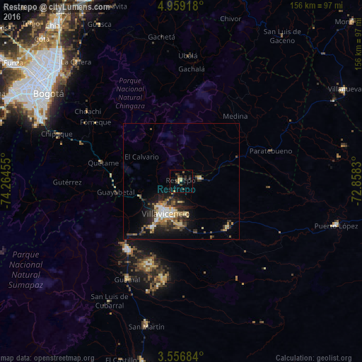
Analysis of Restrepo night lights 2016
Square area 10x10 km:
 0%
0%90-99
0.22%80-89
3.25%70-79
1.73%60-69
0%50-59
2.16%40-49
3.46%30-39
1.95%20-29
4.55%10-19
0.43%0-9
82.25%Square area 50x50 km:
0.9%90-99
0.82%80-89
1.24%70-79
0.78%60-69
0.86%50-59
1.11%40-49
1.19%30-39
1.37%20-29
2.45%10-19
4.37%0-9
84.9%Clear (daylight) street map image can be seen on geolist.org.
Map coordinates:
4° 57' 33" North, 74° 15' 52.4" West
4° 15' 30" North, 73° 33' 41.1" West
3° 33' 24.6" North, 72° 51' 29.9" West
Some cities around Restrepo sort by population:
• Villavicencio
14.8 km =9.2 mi,  209°
209°
• Acacías
37.2 km =23.1 mi,  215°
215°
• San Martín
64.3 km =40 mi,  193°
193°
• Cumaral
8.4 km =5.2 mi,  80°
80°
• La Calera
68.5 km =42.6 mi,  318°
318°
• Cáqueza
45.8 km =28.5 mi,  290°
290°
• Fómeque
45.2 km =28.1 mi,  304°
304°
• Guamal
47.7 km =29.6 mi, 208°
3670855 (p: 7,511)
Sources (retrieved 2019-11-25):
» Earth at Night: Flat Maps 2012, 2016