Illapel night lights from space
Night Light of Illapel (Coquimbo Region) from space (Chile) Src. Average luminocity for 10x10km area is 13.7692% and for 50x50km: 1.1058%.

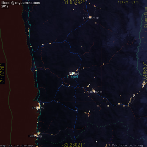
Analysis of Illapel night lights 2016
Square area 10x10 km:
 1.47%
1.47%90-99
0.73%80-89
2.2%70-79
2.2%60-69
3.3%50-59
2.01%40-49
1.1%30-39
3.3%20-29
1.28%10-19
1.1%0-9
81.32%Square area 50x50 km:
0.06%90-99
0.07%80-89
0.28%70-79
0.18%60-69
0.18%50-59
0.15%40-49
0.12%30-39
0.22%20-29
0.11%10-19
0.08%0-9
98.55%Clear (daylight) street map image can be seen on geolist.org.
Map coordinates:
31° 1' 58.5" South, 71° 52' 22.1" West
31° 38' 0.6" South, 71° 10' 10.8" West
32° 13' 48.8" South, 70° 27' 59.6" West
Some cities around Illapel sort by population:
• Ovalle
114.8 km =71.3 mi,  358°
358°
• Quillota
139.2 km =86.5 mi,  183°
183°
• San Felipe
131 km =81.4 mi,  161°
161°
• Hacienda La Calera
127.9 km =79.5 mi, 181°
• La Ligua
91.2 km =56.7 mi, 183°
• Llaillay
135.7 km =84.3 mi,  171°
171°
• Monte Patria
106.3 km =66.1 mi,  10°
10°
• Salamanca
25.3 km =15.7 mi,  129°
129°
3887344 (p: 22,816)
Sources (retrieved 2019-11-25):
» Earth at Night: Flat Maps 2012, 2016