Monte Patria night lights from space
Night Light of Monte Patria (Coquimbo Region) from space (Chile) Src. Average luminocity for 10x10km area is 4.1031% and for 50x50km: 2.0388%.
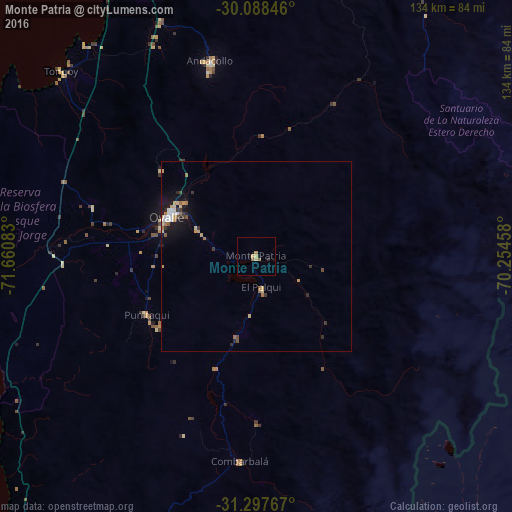
Analysis of Monte Patria night lights 2016
Square area 10x10 km:
 0%
0%90-99
0%80-89
1.22%70-79
1.22%60-69
0.52%50-59
1.22%40-49
0%30-39
0%20-29
0.7%10-19
2.1%0-9
93.01%Square area 50x50 km:
0.24%90-99
0.18%80-89
0.36%70-79
0.33%60-69
0.29%50-59
0.27%40-49
0.13%30-39
0.34%20-29
0.26%10-19
1.62%0-9
95.99%Clear (daylight) street map image can be seen on geolist.org.
Map coordinates:
30° 5' 18.5" South, 71° 39' 39" West
30° 41' 41.9" South, 70° 57' 27.7" West
31° 17' 51.6" South, 70° 15' 16.5" West
Some cities around Monte Patria sort by population:
• Coquimbo
90.2 km =56 mi,  336°
336°
• La Serena
92.2 km =57.3 mi, 342°
• Ovalle
25.3 km =15.7 mi,  294°
294°
• La Ligua
197.1 km =122.5 mi,  187°
187°
• Illapel
106.3 km =66.1 mi, 190°
• Vicuña
77 km =47.8 mi,  17°
17°
• Salamanca
120.6 km =74.9 mi,  180°
180°
• Calingasta, AR
162.8 km =101.2 mi,  115°
115°
3879429 (p: 13,945)
Sources (retrieved 2019-11-25):
» Earth at Night: Flat Maps 2012, 2016