Weinfelden night lights from space
Night Light of Weinfelden (Thurgau) from space (Switzerland) Src. Average luminocity for 10x10km area is 3.5582% and for 50x50km: 6.8785%.
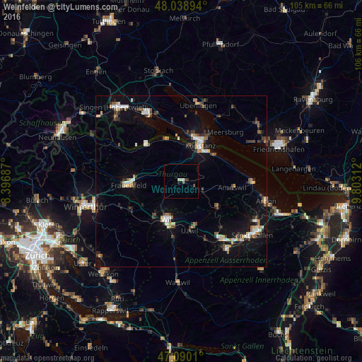
Analysis of Weinfelden night lights 2016
Square area 10x10 km:
 0%
0%90-99
0.57%80-89
1.14%70-79
0%60-69
0.14%50-59
0.43%40-49
1.14%30-39
0.57%20-29
0.57%10-19
0%0-9
95.45%Square area 50x50 km:
0.77%90-99
1.05%80-89
0.76%70-79
0.63%60-69
0.7%50-59
0.72%40-49
1.02%30-39
1.03%20-29
1.06%10-19
4.96%0-9
87.3%Clear (daylight) street map image can be seen on geolist.org.
Map coordinates:
48° 2' 20.2" North, 8° 23' 48.7" East
47° 34' 0" North, 9° 6' 0" East
47° 5' 24.4" North, 9° 48' 11.2" East
Some cities around Weinfelden sort by population:
• Konstanz, DE
11.9 km =7.4 mi,  28°
28°
• Frauenfeld
15.1 km =9.4 mi,  266°
266°
• Kreuzlingen
10.9 km =6.8 mi, 31°
• Wil
12.4 km =7.7 mi,  199°
199°
• Uzwil
14.7 km =9.1 mi,  169°
169°
• Amriswil
14.9 km =9.3 mi,  98°
98°
• Sirnach
13.9 km =8.6 mi,  213°
213°
• Reichenau, DE
13.9 km =8.6 mi,  348°
348°
2658036 (p: 9,414)
Sources (retrieved 2019-11-25):
» Earth at Night: Flat Maps 2012, 2016