Wil night lights from space
Night Light of Wil (Saint Gallen) from space (Switzerland) Src. Average luminocity for 10x10km area is 16.2386% and for 50x50km: 6.0859%.
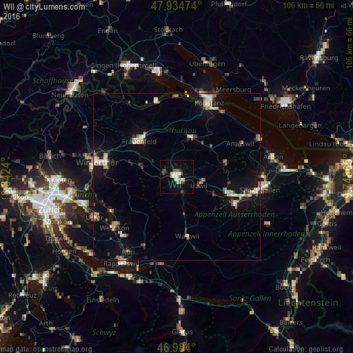
Analysis of Wil night lights 2016
Square area 10x10 km:
 2.13%
2.13%90-99
2.56%80-89
2.27%70-79
1.56%60-69
2.27%50-59
0.14%40-49
3.69%30-39
1.42%20-29
1.85%10-19
9.66%0-9
72.44%Square area 50x50 km:
0.61%90-99
0.93%80-89
0.67%70-79
0.79%60-69
0.69%50-59
0.49%40-49
0.81%30-39
0.79%20-29
0.88%10-19
4.73%0-9
88.61%Clear (daylight) street map image can be seen on geolist.org.
Map coordinates:
47° 56' 5.1" North, 8° 20' 32.6" East
47° 27' 41.5" North, 9° 2' 43.9" East
46° 59' 2.4" North, 9° 44' 55.1" East
Some cities around Wil sort by population:
• Frauenfeld
15.4 km =9.6 mi,  314°
314°
• Uzwil
7.2 km =4.5 mi,  112°
112°
• Flawil
11.7 km =7.3 mi,  117°
117°
• Weinfelden
12.4 km =7.7 mi,  19°
19°
• Kirchberg
5.6 km =3.5 mi,  184°
184°
• Aadorf
11.4 km =7.1 mi,  287°
287°
• Sirnach
3.6 km =2.2 mi,  271°
271°
• Oberuzwil
7 km =4.3 mi, 119°
2657996 (p: 16,808)
Sources (retrieved 2019-11-25):
» Earth at Night: Flat Maps 2012, 2016