Reichenau night lights from space
Night Light of Reichenau (Baden-Württemberg) from space (Germany) Src. Average luminocity for 10x10km area is 5.2366% and for 50x50km: 4.9159%.
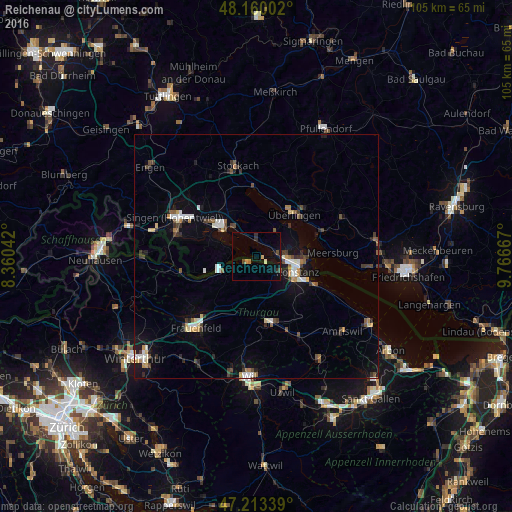
Analysis of Reichenau night lights 2016
Square area 10x10 km:
 0%
0%90-99
0.6%80-89
0.6%70-79
0.6%60-69
0.45%50-59
0.15%40-49
1.49%30-39
0.3%20-29
1.79%10-19
2.68%0-9
91.37%Square area 50x50 km:
0.56%90-99
0.77%80-89
0.45%70-79
0.46%60-69
0.43%50-59
0.57%40-49
0.71%30-39
0.86%20-29
0.83%10-19
2.83%0-9
91.51%Clear (daylight) street map image can be seen on geolist.org.
Map coordinates:
48° 9' 36.1" North, 8° 21' 37.5" East
47° 41' 19.9" North, 9° 3' 48.8" East
47° 12' 48.2" North, 9° 46' 0" East
Some cities around Reichenau sort by population:
• Konstanz
9 km =5.6 mi,  110°
110°
• Radolfzell
9.1 km =5.7 mi,  310°
310°
• Überlingen
12.1 km =7.5 mi,  41°
41°
• Kreuzlingen, CH
9.4 km =5.8 mi,  117°
117°
• Weinfelden, CH
13.9 km =8.6 mi,  168°
168°
• Uhldingen-Mühlhofen
14.8 km =9.2 mi,  70°
70°
• Allensbach
3 km =1.9 mi,  11°
11°
• Meersburg
15.5 km =9.6 mi,  87°
87°
3209418 (p: 5,144)
Sources (retrieved 2019-11-25):
» Earth at Night: Flat Maps 2012, 2016