Kreuzlingen night lights from space
Night Light of Kreuzlingen (Thurgau) from space (Switzerland) Src. Average luminocity for 10x10km area is 23.6741% and for 50x50km: 6.4673%.
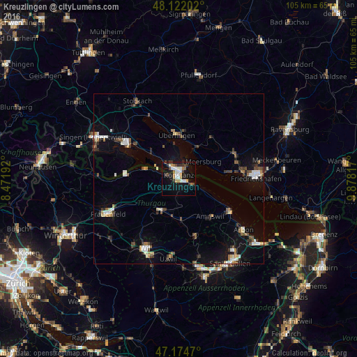
Analysis of Kreuzlingen night lights 2016
Square area 10x10 km:
 3.57%
3.57%90-99
5.8%80-89
0.3%70-79
4.02%60-69
2.98%50-59
0.74%40-49
3.57%30-39
3.57%20-29
2.68%10-19
22.77%0-9
50%Square area 50x50 km:
0.84%90-99
1%80-89
0.61%70-79
0.47%60-69
0.67%50-59
0.7%40-49
1.11%30-39
1.05%20-29
0.92%10-19
4.36%0-9
88.28%Clear (daylight) street map image can be seen on geolist.org.
Map coordinates:
48° 7' 19.3" North, 8° 28' 18.9" East
47° 39' 1.8" North, 9° 10' 30.1" East
47° 10' 28.9" North, 9° 52' 41.4" East
Some cities around Kreuzlingen sort by population:
• Konstanz, DE
1.1 km =0.7 mi,  3°
3°
• Überlingen, DE
13.3 km =8.3 mi,  358°
358°
• Weinfelden
10.9 km =6.8 mi,  211°
211°
• Uhldingen-Mühlhofen, DE
10.8 km =6.7 mi,  31°
31°
• Allensbach, DE
10.6 km =6.6 mi,  312°
312°
• Immenstaad am Bodensee, DE
14.5 km =9 mi,  82°
82°
• Meersburg, DE
8.7 km =5.4 mi,  55°
55°
• Reichenau, DE
9.4 km =5.8 mi,  297°
297°
2660108 (p: 17,655)
Sources (retrieved 2019-11-25):
» Earth at Night: Flat Maps 2012, 2016