Amriswil night lights from space
Night Light of Amriswil (Thurgau) from space (Switzerland) Src. Average luminocity for 10x10km area is 1.7784% and for 50x50km: 7.4852%.
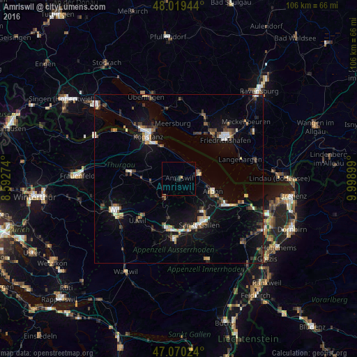
Analysis of Amriswil night lights 2016
Square area 10x10 km:
 0%
0%90-99
0%80-89
0%70-79
0.57%60-69
0.28%50-59
0.14%40-49
0.14%30-39
1.14%20-29
0.43%10-19
1.28%0-9
96.02%Square area 50x50 km:
0.75%90-99
1.07%80-89
0.72%70-79
0.61%60-69
0.82%50-59
0.75%40-49
1.34%30-39
1.35%20-29
1.16%10-19
6.63%0-9
84.81%Clear (daylight) street map image can be seen on geolist.org.
Map coordinates:
48° 1' 10" North, 8° 35' 33.9" East
47° 32' 49.2" North, 9° 17' 45.1" East
47° 4' 12.9" North, 9° 59' 56.4" East
Some cities around Amriswil sort by population:
• Sankt Gallen
14.9 km =9.3 mi,  156°
156°
• Kreuzlingen
14.6 km =9.1 mi,  321°
321°
• Gossau
14.9 km =9.3 mi,  191°
191°
• Arbon
10.9 km =6.8 mi,  108°
108°
• Weinfelden
14.9 km =9.3 mi,  278°
278°
• Romanshorn
6.6 km =4.1 mi,  71°
71°
• Wittenbach
11.7 km =7.3 mi,  144°
144°
• Immenstaad am Bodensee, DE
14.3 km =8.9 mi,  21°
21°
2661756 (p: 11,351)
Sources (retrieved 2019-11-25):
» Earth at Night: Flat Maps 2012, 2016