Unterägeri night lights from space
Night Light of Unterägeri (Zug) from space (Switzerland) Src. Average luminocity for 10x10km area is 4.6776% and for 50x50km: 10.3613%.
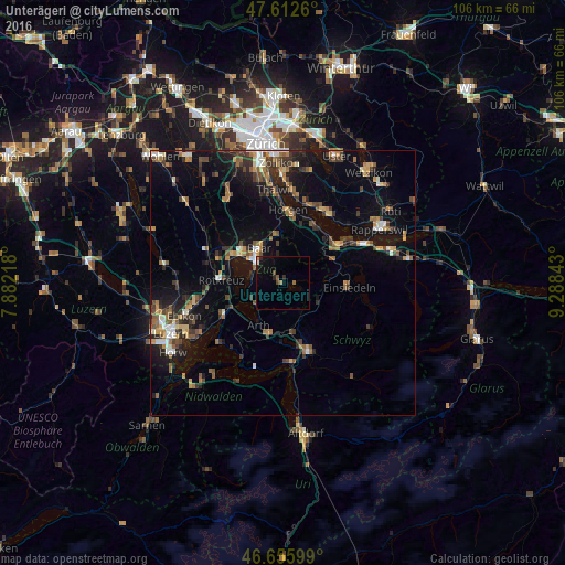
Analysis of Unterägeri night lights 2016
Square area 10x10 km:
 0%
0%90-99
0.57%80-89
0%70-79
0.43%60-69
0.71%50-59
1.14%40-49
1.14%30-39
0.14%20-29
1.56%10-19
2.98%0-9
91.34%Square area 50x50 km:
0.74%90-99
1.15%80-89
0.77%70-79
1.27%60-69
1.9%50-59
1.45%40-49
2.04%30-39
1.89%20-29
2.65%10-19
7.76%0-9
78.35%Clear (daylight) street map image can be seen on geolist.org.
Map coordinates:
47° 36' 45.4" North, 7° 52' 55.8" East
47° 8' 11.2" North, 8° 35' 7.1" East
46° 39' 21.6" North, 9° 17' 18.3" East
Some cities around Unterägeri sort by population:
• Zug
6.5 km =4 mi,  307°
307°
• Baar
7.9 km =4.9 mi,  327°
327°
• Cham
10.5 km =6.5 mi,  298°
298°
• Rotkreuz
11.7 km =7.3 mi,  273°
273°
• Richterswil
11.5 km =7.1 mi,  47°
47°
• Arth
9.4 km =5.8 mi,  209°
209°
• Steinhausen
10 km =6.2 mi, 310°
• Goldau
10.3 km =6.4 mi,  196°
196°
2658264 (p: 7,973)
Sources (retrieved 2019-11-25):
» Earth at Night: Flat Maps 2012, 2016