Steinhausen night lights from space
Night Light of Steinhausen (Zug) from space (Switzerland) Src. Average luminocity for 10x10km area is 21.8735% and for 50x50km: 15.7713%.
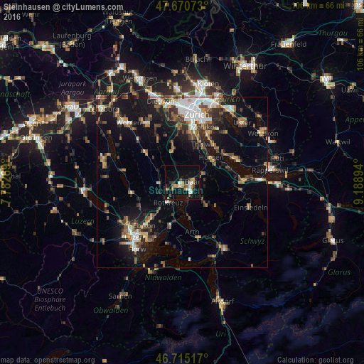
Analysis of Steinhausen night lights 2016
Square area 10x10 km:
 1.64%
1.64%90-99
3.57%80-89
0.89%70-79
5.65%60-69
2.53%50-59
3.13%40-49
1.93%30-39
2.53%20-29
2.68%10-19
26.19%0-9
49.26%Square area 50x50 km:
2.22%90-99
2.24%80-89
1.14%70-79
1.58%60-69
2.52%50-59
2.19%40-49
2.7%30-39
2.75%20-29
3.67%10-19
11.82%0-9
67.17%Clear (daylight) street map image can be seen on geolist.org.
Map coordinates:
47° 40' 14.6" North, 7° 46' 57.7" East
47° 11' 42.4" North, 8° 29' 8.9" East
46° 42' 54.6" North, 9° 11' 20.2" East
Some cities around Steinhausen sort by population:
• Zug
3.5 km =2.2 mi,  136°
136°
• Baar
3.3 km =2.1 mi,  87°
87°
• Horgen
11.1 km =6.9 mi,  49°
49°
• Cham
2.2 km =1.4 mi,  229°
229°
• Rotkreuz
7.1 km =4.4 mi,  215°
215°
• Hünenberg
5.1 km =3.2 mi,  244°
244°
• Affoltern am Albis
9.5 km =5.9 mi,  344°
344°
• Unterägeri
10 km =6.2 mi,  130°
130°
2658483 (p: 8,509)
Sources (retrieved 2019-11-25):
» Earth at Night: Flat Maps 2012, 2016