Lutry night lights from space
Night Light of Lutry (Vaud) from space (Switzerland) Src. Average luminocity for 10x10km area is 29.7884% and for 50x50km: 12.0339%.
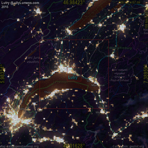
Analysis of Lutry night lights 2016
Square area 10x10 km:
 7.24%
7.24%90-99
7.39%80-89
1.99%70-79
1.42%60-69
2.84%50-59
4.69%40-49
1.56%30-39
1.99%20-29
9.8%10-19
20.45%0-9
40.63%Square area 50x50 km:
1.47%90-99
1.96%80-89
0.88%70-79
1.13%60-69
1.49%50-59
1.4%40-49
1.92%30-39
1.83%20-29
3.09%10-19
10.56%0-9
74.27%Clear (daylight) street map image can be seen on geolist.org.
Map coordinates:
46° 59' 3.2" North, 5° 59' 0" East
46° 30' 8.7" North, 6° 41' 11.3" East
46° 0' 58.6" North, 7° 23' 22.5" East
Some cities around Lutry sort by population:
• Lausanne
4.4 km =2.7 mi,  290°
290°
• Renens
8.6 km =5.3 mi,  298°
298°
• Pully
2.1 km =1.3 mi, 294°
• Prilly
7.4 km =4.6 mi, 301°
• Epalinges
5.4 km =3.4 mi,  344°
344°
• Blécherette
6.4 km =4 mi,  309°
309°
• Chavannes
9.4 km =5.8 mi, 289°
• Le Mont-sur-Lausanne
7.5 km =4.7 mi,  325°
325°
2659819 (p: 8,774)
Sources (retrieved 2019-11-25):
» Earth at Night: Flat Maps 2012, 2016