Renens night lights from space
Night Light of Renens (Vaud) from space (Switzerland) Src. Average luminocity for 10x10km area is 60.2827% and for 50x50km: 12.0786%.
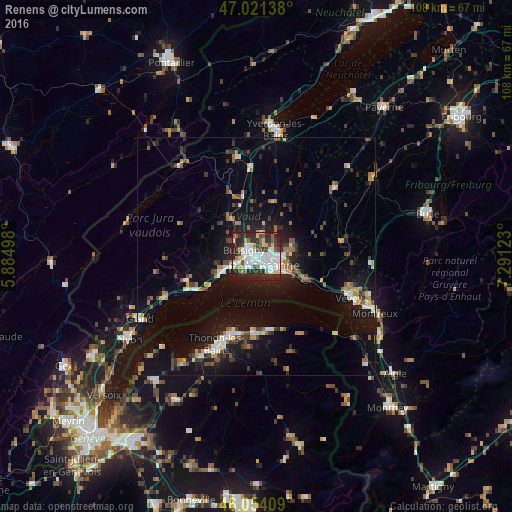
Analysis of Renens night lights 2016
Square area 10x10 km:
 17.19%
90-99
18.04%80-89
6.39%70-79
2.84%60-69
3.55%50-59
5.11%40-49
5.82%30-39
8.38%20-29
27.98%10-19
4.69%0-9
0%Square area 50x50 km:
1.49%90-99
1.87%80-89
0.9%70-79
1.17%60-69
1.46%50-59
1.48%40-49
1.73%30-39
2.02%20-29
3.19%10-19
10.7%0-9
74%Clear (daylight) street map image can be seen on geolist.org.
Map coordinates:
47° 1' 17" North, 5° 53' 5.9" East
46° 32' 23.6" North, 6° 35' 17.2" East
46° 3' 14.7" North, 7° 17' 28.4" East
Some cities around Renens sort by population:
• Lausanne
4.3 km =2.7 mi,  127°
127°
• Prilly
1.3 km =0.8 mi,  104°
104°
• Ecublens
2.3 km =1.4 mi,  238°
238°
• Bussigny
2.8 km =1.7 mi,  296°
296°
• Crissier
1.2 km =0.7 mi, 304°
• Blécherette
2.6 km =1.6 mi,  91°
91°
• Chavannes
1.7 km =1.1 mi,  230°
230°
• Le Mont-sur-Lausanne
3.9 km =2.4 mi,  58°
58°
2659070 (p: 17,811)
Sources (retrieved 2019-11-25):
» Earth at Night: Flat Maps 2012, 2016