Prilly night lights from space
Night Light of Prilly (Vaud) from space (Switzerland) Src. Average luminocity for 10x10km area is 61.3594% and for 50x50km: 12.2462%.
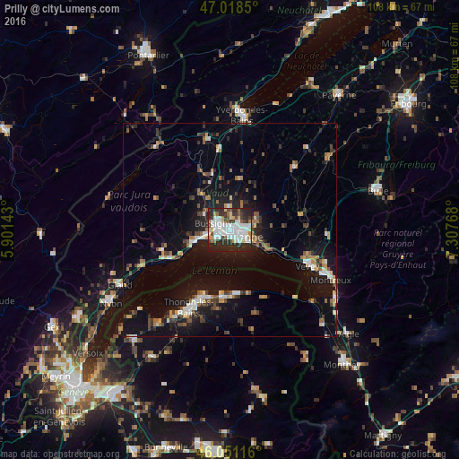
Analysis of Prilly night lights 2016
Square area 10x10 km:
 17.9%
17.9%90-99
19.74%80-89
5.54%70-79
2.13%60-69
4.4%50-59
4.55%40-49
5.26%30-39
9.23%20-29
26.56%10-19
4.69%0-9
0%Square area 50x50 km:
1.48%90-99
1.93%80-89
0.91%70-79
1.23%60-69
1.51%50-59
1.43%40-49
1.82%30-39
2%20-29
3.2%10-19
10.64%0-9
73.85%Clear (daylight) street map image can be seen on geolist.org.
Map coordinates:
47° 1' 6.6" North, 5° 54' 5.1" East
46° 32' 13.1" North, 6° 36' 16.4" East
46° 3' 4.2" North, 7° 18' 27.6" East
Some cities around Prilly sort by population:
• Lausanne
3.2 km =2 mi,  137°
137°
• Renens
1.3 km =0.8 mi,  284°
284°
• Ecublens
3.3 km =2.1 mi,  254°
254°
• Bussigny
4 km =2.5 mi,  292°
292°
• Crissier
2.4 km =1.5 mi, 294°
• Blécherette
1.4 km =0.9 mi,  79°
79°
• Chavannes
2.7 km =1.7 mi, 253°
• Le Mont-sur-Lausanne
3.1 km =1.9 mi,  41°
41°
2659136 (p: 10,524)
Sources (retrieved 2019-11-25):
» Earth at Night: Flat Maps 2012, 2016