Ecublens night lights from space
Night Light of Ecublens (Fribourg) from space (Switzerland) Src. Average luminocity for 10x10km area is 3.1392% and for 50x50km: 11.0745%.
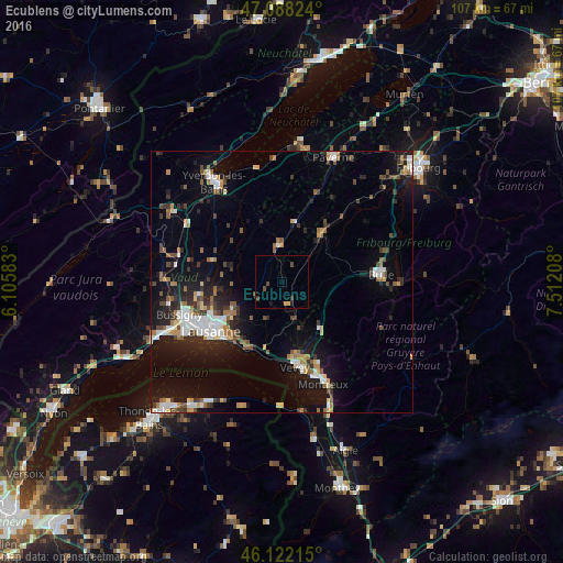
Analysis of Ecublens night lights 2016
Square area 10x10 km:
 0%
0%90-99
0%80-89
0.28%70-79
0.85%60-69
0%50-59
0%40-49
1.99%30-39
1.14%20-29
0%10-19
1.42%0-9
94.32%Square area 50x50 km:
1.62%90-99
1.79%80-89
0.79%70-79
1.1%60-69
1.34%50-59
1.41%40-49
1.57%30-39
1.6%20-29
2.9%10-19
8.49%0-9
77.4%Clear (daylight) street map image can be seen on geolist.org.
Map coordinates:
47° 5' 17.7" North, 6° 6' 21" East
46° 36' 26.5" North, 6° 48' 32.2" East
46° 7' 19.7" North, 7° 30' 43.5" East
Some cities around Ecublens sort by population:
• Pully
15.6 km =9.7 mi,  226°
226°
• Vevey
16.3 km =10.1 mi,  170°
170°
• Lutry
15 km =9.3 mi,  218°
218°
• Epalinges
12.6 km =7.8 mi,  238°
238°
• Blécherette
16.1 km =10 mi, 242°
• Le Mont-sur-Lausanne
14.6 km =9.1 mi,  248°
248°
• Blonay
16.9 km =10.5 mi,  156°
156°
• Châtel-Saint-Denis
11.4 km =7.1 mi,  141°
141°
2660947 (p: 10,065)
Sources (retrieved 2019-11-25):
» Earth at Night: Flat Maps 2012, 2016