Vevey night lights from space
Night Light of Vevey (Vaud) from space (Switzerland) Src. Average luminocity for 10x10km area is 23.6122% and for 50x50km: 10.0751%.
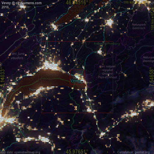
Analysis of Vevey night lights 2016
Square area 10x10 km:
 3.55%
3.55%90-99
3.84%80-89
2.13%70-79
3.55%60-69
3.98%50-59
3.27%40-49
0.71%30-39
0.99%20-29
2.41%10-19
31.53%0-9
44.03%Square area 50x50 km:
1.35%90-99
1.62%80-89
0.84%70-79
0.9%60-69
1.2%50-59
1.34%40-49
1.6%30-39
1.44%20-29
2.59%10-19
7.97%0-9
79.14%Clear (daylight) street map image can be seen on geolist.org.
Map coordinates:
46° 56' 42.6" North, 6° 8' 25.2" East
46° 27' 46.8" North, 6° 50' 36.4" East
45° 58' 35.4" North, 7° 32' 47.7" East
Some cities around Vevey sort by population:
• Montreux
6.2 km =3.9 mi,  122°
122°
• Pully
14.9 km =9.3 mi,  290°
290°
• La Tour-de-Peilz
1.6 km =1 mi,  133°
133°
• Ecublens
16.3 km =10.1 mi,  350°
350°
• Lutry
12.8 km =8 mi, 290°
• Epalinges
16.5 km =10.3 mi,  305°
305°
• Blonay
4.1 km =2.5 mi,  82°
82°
• Châtel-Saint-Denis
8.4 km =5.2 mi,  31°
31°
2658145 (p: 15,812)
Sources (retrieved 2019-11-25):
» Earth at Night: Flat Maps 2012, 2016