Immenstaad am Bodensee night lights from space
Night Light of Immenstaad am Bodensee (Baden-Württemberg) from space (Germany) Src. Average luminocity for 10x10km area is 4.9896% and for 50x50km: 6.2625%.
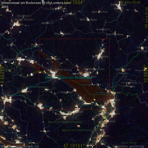
Analysis of Immenstaad am Bodensee night lights 2016
Square area 10x10 km:
 0%
0%90-99
0%80-89
0%70-79
0%60-69
0.89%50-59
0.89%40-49
2.23%30-39
3.42%20-29
0.6%10-19
1.79%0-9
90.18%Square area 50x50 km:
0.6%90-99
0.88%80-89
0.58%70-79
0.48%60-69
0.78%50-59
0.78%40-49
1.26%30-39
1.01%20-29
1.13%10-19
4.94%0-9
87.56%Clear (daylight) street map image can be seen on geolist.org.
Map coordinates:
48° 8' 16.9" North, 8° 39' 48.8" East
47° 40' 0" North, 9° 22' 0" East
47° 11' 27.6" North, 10° 4' 11.3" East
Some cities around Immenstaad am Bodensee sort by population:
• Konstanz
14.3 km =8.9 mi,  267°
267°
• Friedrichshafen
8.2 km =5.1 mi,  97°
97°
• Markdorf
6.1 km =3.8 mi,  16°
16°
• Amriswil, CH
14.3 km =8.9 mi,  201°
201°
• Salem
12.1 km =7.5 mi,  331°
331°
• Romanshorn, CH
11.2 km =7 mi,  175°
175°
• Uhldingen-Mühlhofen
11.5 km =7.1 mi,  310°
310°
• Meersburg
7.8 km =4.8 mi,  293°
293°
2896263 (p: 5,946)
Sources (retrieved 2019-11-25):
» Earth at Night: Flat Maps 2012, 2016