Wittenbach night lights from space
Night Light of Wittenbach (Saint Gallen) from space (Switzerland) Src. Average luminocity for 10x10km area is 23.0142% and for 50x50km: 9.0564%.
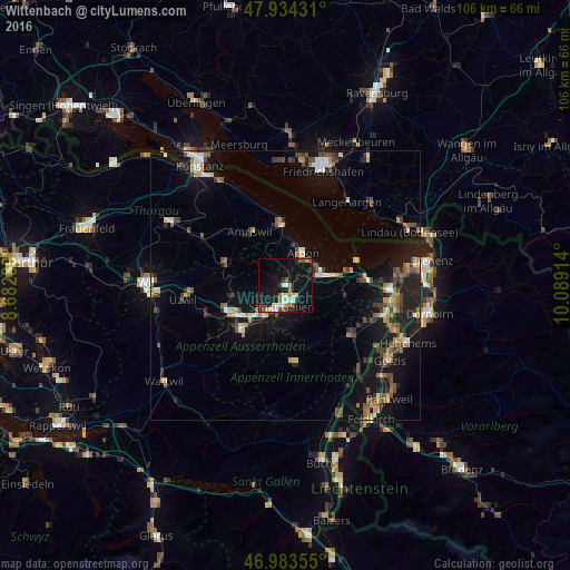
Analysis of Wittenbach night lights 2016
Square area 10x10 km:
 3.41%
3.41%90-99
4.26%80-89
2.13%70-79
1.42%60-69
3.98%50-59
1.42%40-49
2.56%30-39
3.13%20-29
3.13%10-19
32.95%0-9
41.62%Square area 50x50 km:
0.65%90-99
1.12%80-89
0.76%70-79
0.98%60-69
1.45%50-59
1.3%40-49
1.83%30-39
1.42%20-29
2.11%10-19
9.14%0-9
79.22%Clear (daylight) street map image can be seen on geolist.org.
Map coordinates:
47° 56' 3.5" North, 8° 40' 58.4" East
47° 27' 39.9" North, 9° 23' 9.6" East
46° 59' 0.8" North, 10° 5' 20.9" East
Some cities around Wittenbach sort by population:
• Sankt Gallen
4.2 km =2.6 mi,  191°
191°
• Gossau
11.1 km =6.9 mi,  242°
242°
• Herisau
11.6 km =7.2 mi,  223°
223°
• Arbon
7.1 km =4.4 mi,  29°
29°
• Amriswil
11.7 km =7.3 mi,  324°
324°
• Goldach
6.3 km =3.9 mi,  76°
76°
• Rorschach
8.1 km =5 mi, 76°
• Teufen
7.8 km =4.8 mi,  179°
179°
2657968 (p: 8,542)
Sources (retrieved 2019-11-25):
» Earth at Night: Flat Maps 2012, 2016