Altstätten night lights from space
Night Light of Altstätten (Saint Gallen) from space (Switzerland) Src. Average luminocity for 10x10km area is 7.2857% and for 50x50km: 9.3901%.
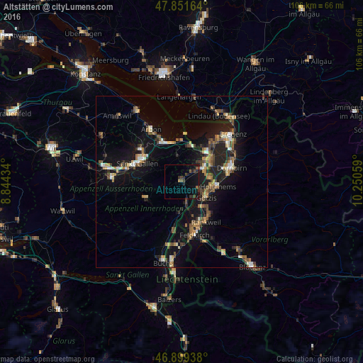
Analysis of Altstätten night lights 2016
Square area 10x10 km:
 0%
0%90-99
0%80-89
0%70-79
0.6%60-69
0.74%50-59
1.93%40-49
1.49%30-39
2.98%20-29
3.27%10-19
8.78%0-9
80.21%Square area 50x50 km:
0.54%90-99
1.15%80-89
0.87%70-79
1.12%60-69
1.48%50-59
1.63%40-49
1.74%30-39
1.35%20-29
2.18%10-19
9.74%0-9
78.19%Clear (daylight) street map image can be seen on geolist.org.
Map coordinates:
47° 51' 5.9" North, 8° 50' 39.6" East
47° 22' 39.6" North, 9° 32' 50.9" East
46° 53' 57.8" North, 10° 15' 2.1" East
Some cities around Altstätten sort by population:
• Lustenau, AT
10 km =6.2 mi,  57°
57°
• Hohenems, AT
10.3 km =6.4 mi,  96°
96°
• Götzis, AT
8.1 km =5 mi,  127°
127°
• Oberriet
6.5 km =4 mi,  166°
166°
• Au
8.8 km =5.5 mi,  47°
47°
• Altach, AT
8.3 km =5.2 mi,  111°
111°
• Thal
10 km =6.2 mi,  8°
8°
• Diepoldsau
8.2 km =5.1 mi,  83°
83°
2661766 (p: 10,574)
Sources (retrieved 2019-11-25):
» Earth at Night: Flat Maps 2012, 2016