Götzis night lights from space
Night Light of Götzis (Vorarlberg) from space (Austria) Src. Average luminocity for 10x10km area is 22.0774% and for 50x50km: 8.9285%.
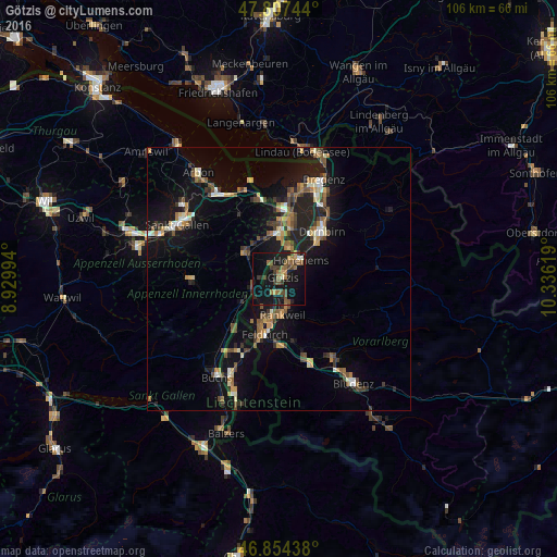
Analysis of Götzis night lights 2016
Square area 10x10 km:
 0.3%
0.3%90-99
1.49%80-89
0.6%70-79
1.93%60-69
5.95%50-59
5.51%40-49
5.36%30-39
4.91%20-29
4.17%10-19
35.12%0-9
34.67%Square area 50x50 km:
0.49%90-99
1.11%80-89
0.75%70-79
1.1%60-69
1.41%50-59
1.5%40-49
1.71%30-39
1.34%20-29
2.21%10-19
9.36%0-9
79.04%Clear (daylight) street map image can be seen on geolist.org.
Map coordinates:
47° 48' 26.8" North, 8° 55' 47.8" East
47° 19' 59" North, 9° 37' 59" East
46° 51' 15.8" North, 10° 20' 10.3" East
Some cities around Götzis sort by population:
• Lustenau
10.6 km =6.6 mi,  10°
10°
• Hohenems
5.3 km =3.3 mi,  45°
45°
• Rankweil
6.9 km =4.3 mi,  173°
173°
• Altstätten, CH
8.1 km =5 mi,  307°
307°
• Oberriet, CH
5.1 km =3.2 mi,  254°
254°
• Au, CH
10.9 km =6.8 mi,  0°
0°
• Altach
2.3 km =1.4 mi,  34°
34°
• Diepoldsau, CH
6.1 km =3.8 mi,  16°
16°
2778218 (p: 11,473)
Sources (retrieved 2019-11-25):
» Earth at Night: Flat Maps 2012, 2016