Oromocto night lights from space
Night Light of Oromocto (New Brunswick) from space (Canada) Src. Average luminocity for 10x10km area is 19.9152% and for 50x50km: 3.608%.
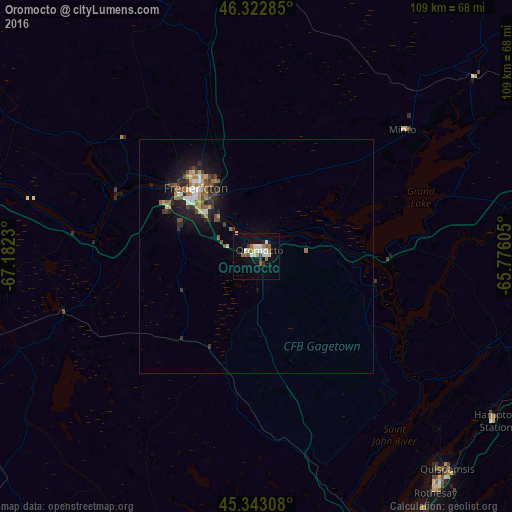
Analysis of Oromocto night lights 2016
Square area 10x10 km:
 2.23%
2.23%90-99
6.4%80-89
1.19%70-79
0%60-69
4.91%50-59
2.08%40-49
0.74%30-39
1.79%20-29
0.45%10-19
17.56%0-9
62.65%Square area 50x50 km:
0.37%90-99
0.55%80-89
0.33%70-79
0.34%60-69
0.55%50-59
0.52%40-49
0.66%30-39
0.53%20-29
0.86%10-19
2.94%0-9
92.36%Clear (daylight) street map image can be seen on geolist.org.
Map coordinates:
46° 19' 22.3" North, 67° 10' 56.3" West
45° 50' 6.4" North, 66° 28' 45" West
45° 20' 35.1" North, 65° 46' 33.8" West
Some cities around Oromocto sort by population:
• Moncton
133.2 km =82.8 mi,  77°
77°
• Saint John
70.3 km =43.7 mi,  152°
152°
• Fredericton
18.9 km =11.7 mi,  310°
310°
• Dieppe
141.1 km =87.7 mi, 78°
• Lutes Mountain
126.1 km =78.4 mi,  74°
74°
• Presque Isle, US
151 km =93.8 mi, 308°
• Sussex
76.4 km =47.5 mi,  99°
99°
• Houlton, US
110 km =68.4 mi,  287°
287°
6094407 (p: 8,805)
Sources (retrieved 2019-11-25):
» Earth at Night: Flat Maps 2012, 2016