Collingwood night lights from space
Night Light of Collingwood (Ontario) from space (Canada) Src. Average luminocity for 10x10km area is 25.6079% and for 50x50km: 3.2655%.
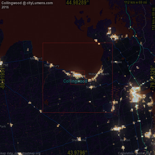
Analysis of Collingwood night lights 2016
Square area 10x10 km:
 1.59%
1.59%90-99
3.81%80-89
2.54%70-79
5.08%60-69
5.08%50-59
4.92%40-49
3.33%30-39
2.7%20-29
1.43%10-19
27.78%0-9
41.75%Square area 50x50 km:
0.06%90-99
0.42%80-89
0.59%70-79
0.4%60-69
0.45%50-59
0.48%40-49
0.52%30-39
0.49%20-29
0.41%10-19
2.37%0-9
93.8%Clear (daylight) street map image can be seen on geolist.org.
Map coordinates:
44° 58' 58.4" North, 80° 55' 10.2" West
44° 29' 0.2" North, 80° 12' 59" West
43° 58' 46.6" North, 79° 30' 47.7" West
Some cities around Collingwood sort by population:
• Barrie
44.6 km =27.7 mi,  101°
101°
• Midland
39.7 km =24.7 mi,  41°
41°
• Owen Sound
58.4 km =36.3 mi,  279°
279°
• Alliston
46.4 km =28.8 mi,  143°
143°
• Angus
32.3 km =20.1 mi,  124°
124°
• Shelburne
45 km =28 mi,  178°
178°
• Wasaga Beach
16.3 km =10.1 mi,  76°
76°
• Innisfil
49.4 km =30.7 mi,  114°
114°
5925975 (p: 15,809)
Sources (retrieved 2019-11-25):
» Earth at Night: Flat Maps 2012, 2016