Innisfil night lights from space
Night Light of Innisfil (Ontario) from space (Canada) Src. Average luminocity for 10x10km area is 28.5591% and for 50x50km: 11.6542%.
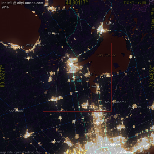
Analysis of Innisfil night lights 2016
Square area 10x10 km:
 5.45%
5.45%90-99
5%80-89
1.67%70-79
2.42%60-69
2.27%50-59
4.09%40-49
1.82%30-39
3.48%20-29
16.21%10-19
28.18%0-9
29.39%Square area 50x50 km:
1.08%90-99
1.61%80-89
1.54%70-79
1.57%60-69
1.31%50-59
1.56%40-49
1.57%30-39
2.03%20-29
3.56%10-19
8.84%0-9
75.34%Clear (daylight) street map image can be seen on geolist.org.
Map coordinates:
44° 48' 4.2" North, 80° 21' 10" West
44° 18' 0.4" North, 79° 38' 58.7" West
43° 47' 41" North, 78° 56' 47.5" West
Some cities around Innisfil sort by population:
• Barrie
11.2 km =7 mi,  353°
353°
• Newmarket
31.4 km =19.5 mi,  152°
152°
• Aurora
36.4 km =22.6 mi,  156°
156°
• East Gwillimbury
27.9 km =17.3 mi,  142°
142°
• Keswick
15.6 km =9.7 mi,  110°
110°
• Alliston
24 km =14.9 mi,  225°
225°
• Angus
18.7 km =11.6 mi,  275°
275°
• Tottenham
33.1 km =20.6 mi,  202°
202°
5983433 (p: 7,345)
Sources (retrieved 2019-11-25):
» Earth at Night: Flat Maps 2012, 2016