Shelburne night lights from space
Night Light of Shelburne (Ontario) from space (Canada) Src. Average luminocity for 10x10km area is 5.5803% and for 50x50km: 2.0364%.
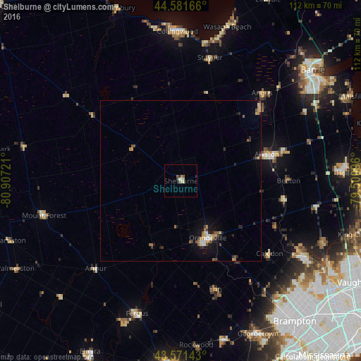
Analysis of Shelburne night lights 2016
Square area 10x10 km:
 0.76%
0.76%90-99
0.61%80-89
1.67%70-79
0.61%60-69
0%50-59
1.82%40-49
0%30-39
0.61%20-29
0.91%10-19
0%0-9
93.03%Square area 50x50 km:
0.15%90-99
0.21%80-89
0.27%70-79
0.32%60-69
0.29%50-59
0.39%40-49
0.16%30-39
0.34%20-29
0.37%10-19
1.3%0-9
96.2%Clear (daylight) street map image can be seen on geolist.org.
Map coordinates:
44° 34' 54" North, 80° 54' 26" West
44° 4' 43.3" North, 80° 12' 14.7" West
43° 34' 17.1" North, 79° 30' 3.5" West
Some cities around Shelburne sort by population:
• Orangeville
19.8 km =12.3 mi,  155°
155°
• Alliston
28.1 km =17.5 mi,  73°
73°
• Collingwood
45 km =28 mi,  358°
358°
• Angus
36.8 km =22.9 mi,  44°
44°
• Wasaga Beach
51 km =31.7 mi,  17°
17°
• Innisfil
50.6 km =31.4 mi,  60°
60°
• King
50.7 km =31.5 mi,  104°
104°
• Tottenham
32.4 km =20.1 mi, 100°
6145890 (p: 8,126)
Sources (retrieved 2019-11-25):
» Earth at Night: Flat Maps 2012, 2016