Wasaga Beach night lights from space
Night Light of Wasaga Beach (Ontario) from space (Canada) Src. Average luminocity for 10x10km area is 17.8651% and for 50x50km: 5.6394%.
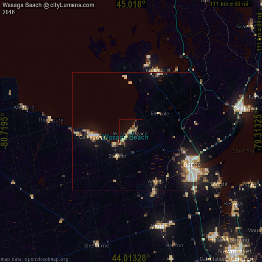
Analysis of Wasaga Beach night lights 2016
Square area 10x10 km:
 0%
0%90-99
2.22%80-89
6.19%70-79
1.9%60-69
0.48%50-59
2.38%40-49
3.49%30-39
2.7%20-29
1.9%10-19
14.44%0-9
64.29%Square area 50x50 km:
0.3%90-99
0.77%80-89
0.94%70-79
0.64%60-69
0.78%50-59
0.75%40-49
0.86%30-39
0.91%20-29
1.32%10-19
3.95%0-9
88.79%Clear (daylight) street map image can be seen on geolist.org.
Map coordinates:
45° 0' 57.6" North, 80° 43' 10.2" West
44° 31' 0.5" North, 80° 0' 58.9" West
44° 0' 47.8" North, 79° 18' 47.7" West
Some cities around Wasaga Beach sort by population:
• Barrie
30.7 km =19.1 mi,  115°
115°
• Orillia
48.3 km =30 mi,  77°
77°
• Midland
28 km =17.4 mi,  22°
22°
• Alliston
42.5 km =26.4 mi,  163°
163°
• Collingwood
16.3 km =10.1 mi,  256°
256°
• Angus
24.6 km =15.3 mi,  154°
154°
• Shelburne
51 km =31.7 mi,  197°
197°
• Innisfil
37.8 km =23.5 mi,  129°
129°
6176421 (p: 7,567)
Sources (retrieved 2019-11-25):
» Earth at Night: Flat Maps 2012, 2016