Corozal night lights from space
Night Light of Corozal from space (Belize) Src. Average luminocity for 10x10km area is 19.8574% and for 50x50km: 5.8557%.
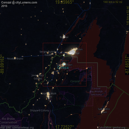
Analysis of Corozal night lights 2016
Square area 10x10 km:
 2.48%
2.48%90-99
2.48%80-89
4.13%70-79
1.24%60-69
3.51%50-59
3.51%40-49
1.24%30-39
0.41%20-29
1.65%10-19
16.94%0-9
62.4%Square area 50x50 km:
0.68%90-99
0.72%80-89
1.05%70-79
0.62%60-69
0.75%50-59
0.65%40-49
0.75%30-39
0.51%20-29
1.26%10-19
4.15%0-9
88.86%Clear (daylight) street map image can be seen on geolist.org.
Map coordinates:
19° 3' 34.7" North, 89° 5' 29.8" West
18° 23' 37.5" North, 88° 23' 18.6" West
17° 43' 31" North, 87° 41' 7.3" West
Some cities around Corozal sort by population:
• Chetumal, MX
16.1 km =10 mi,  33°
33°
• Belize City
101.5 km =63.1 mi,  168°
168°
• Felipe Carrillo Puerto, MX
136.5 km =84.8 mi,  15°
15°
• Orange Walk
39.3 km =24.4 mi,  207°
207°
• Belmopan
133.3 km =82.8 mi,  197°
197°
• Bacalar, MX
32 km =19.9 mi,  359°
359°
• San Pedro
69.4 km =43.1 mi,  139°
139°
• Calderitas, MX
22.8 km =14.2 mi,  37°
37°
3582305 (p: 9,871)
Sources (retrieved 2019-11-25):
» Earth at Night: Flat Maps 2012, 2016