Loshnitsa night lights from space
Night Light of Loshnitsa (Minsk) from space (Belarus) Src. Average luminocity for 10x10km area is 1.5476% and for 50x50km: 2.6116%.
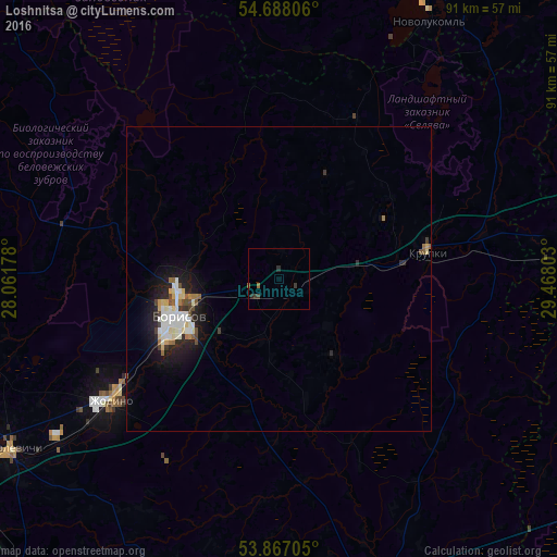
Analysis of Loshnitsa night lights 2016
Square area 10x10 km:
 0%
0%90-99
0%80-89
0%70-79
0%60-69
0.5%50-59
0.5%40-49
0%30-39
1.5%20-29
1%10-19
0%0-9
96.49%Square area 50x50 km:
0.39%90-99
0.64%80-89
0.33%70-79
0.15%60-69
0.26%50-59
0.21%40-49
0.31%30-39
0.25%20-29
0.76%10-19
2.06%0-9
94.65%Clear (daylight) street map image can be seen on geolist.org.
Map coordinates:
54° 41' 17" North, 28° 3' 42.4" East
54° 16' 46.6" North, 28° 45' 53.6" East
53° 52' 1.4" North, 29° 28' 4.9" East
Some cities around Loshnitsa sort by population:
• Barysaw
17.8 km =11.1 mi,  251°
251°
• Horad Zhodzina
34.6 km =21.5 mi,  234°
234°
• Novolukoml’
49.3 km =30.6 mi,  30°
30°
• Byerazino
51.1 km =31.8 mi,  163°
163°
• Horad Smalyavichy
52.3 km =32.5 mi,  237°
237°
• Talachyn
62 km =38.5 mi,  76°
76°
• Lahoysk
59.9 km =37.2 mi,  262°
262°
• Krupki
24.5 km =15.2 mi, 80°
625931 (p: 6,524)
Sources (retrieved 2019-11-25):
» Earth at Night: Flat Maps 2012, 2016