Veranópolis night lights from space
Night Light of Veranópolis (Rio Grande do Sul) from space (Brazil) Src. Average luminocity for 10x10km area is 11.6131% and for 50x50km: 4.0024%.
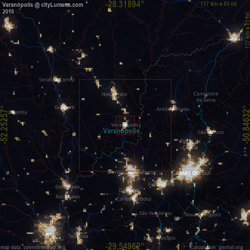
Analysis of Veranópolis night lights 2016
Square area 10x10 km:
 0.79%
0.79%90-99
2.38%80-89
1.59%70-79
0.79%60-69
1.59%50-59
2.78%40-49
1.98%30-39
0.6%20-29
0.2%10-19
0.79%0-9
86.51%Square area 50x50 km:
0.36%90-99
0.44%80-89
0.57%70-79
0.6%60-69
0.39%50-59
0.6%40-49
0.4%30-39
0.69%20-29
0.93%10-19
2.41%0-9
92.61%Clear (daylight) street map image can be seen on geolist.org.
Map coordinates:
28° 19' 8.2" South, 52° 15' 9.3" West
28° 56' 10" South, 51° 32' 58" West
29° 32' 58.6" South, 50° 50' 46.8" West
Some cities around Veranópolis sort by population:
• Caxias do Sul
44.3 km =27.5 mi,  125°
125°
• Bento Gonçalves
26.3 km =16.3 mi,  173°
173°
• Farroupilha
37.6 km =23.4 mi,  148°
148°
• Garibaldi
35.6 km =22.1 mi,  177°
177°
• Flores da Cunha
37.2 km =23.1 mi,  106°
106°
• Guaporé
34.7 km =21.6 mi,  286°
286°
• Carlos Barbosa
40.4 km =25.1 mi, 173°
• Nova Prata
17.9 km =11.1 mi,  340°
340°
3445299 (p: 19,861)
Sources (retrieved 2019-11-25):
» Earth at Night: Flat Maps 2012, 2016