Nova Prata night lights from space
Night Light of Nova Prata (Rio Grande do Sul) from space (Brazil) Src. Average luminocity for 10x10km area is 23.5606% and for 50x50km: 3.3279%.
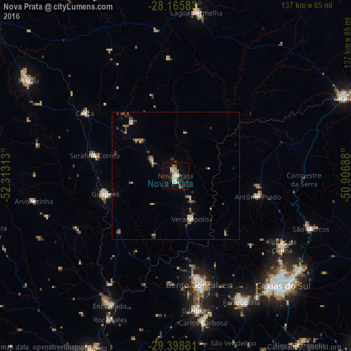
Analysis of Nova Prata night lights 2016
Square area 10x10 km:
 2.84%
2.84%90-99
3.22%80-89
4.92%70-79
4.17%60-69
1.52%50-59
1.33%40-49
4.17%30-39
2.84%20-29
0%10-19
21.21%0-9
53.79%Square area 50x50 km:
0.22%90-99
0.32%80-89
0.49%70-79
0.48%60-69
0.47%50-59
0.46%40-49
0.52%30-39
0.69%20-29
0.51%10-19
1.08%0-9
94.77%Clear (daylight) street map image can be seen on geolist.org.
Map coordinates:
28° 9' 57" South, 52° 18' 47.3" West
28° 47' 2" South, 51° 36' 36" West
29° 23' 53.9" South, 50° 54' 24.8" West
Some cities around Nova Prata sort by population:
• Bento Gonçalves
44 km =27.3 mi,  168°
168°
• Farroupilha
55.3 km =34.4 mi,  152°
152°
• Garibaldi
53 km =32.9 mi, 171°
• Flores da Cunha
49.8 km =30.9 mi,  123°
123°
• Guaporé
28.2 km =17.5 mi,  255°
255°
• Veranópolis
17.9 km =11.1 mi,  160°
160°
• São Marcos
56.7 km =35.2 mi,  111°
111°
• Encantado
56.3 km =35 mi,  206°
206°
3456125 (p: 17,943)
Sources (retrieved 2019-11-25):
» Earth at Night: Flat Maps 2012, 2016