São Marcos night lights from space
Night Light of São Marcos (Rio Grande do Sul) from space (Brazil) Src. Average luminocity for 10x10km area is 13.0119% and for 50x50km: 8.1251%.
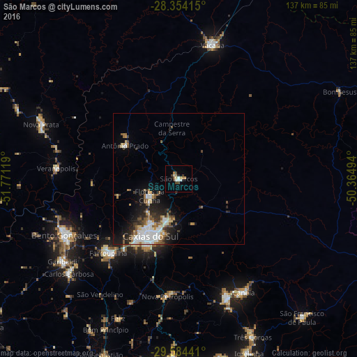
Analysis of São Marcos night lights 2016
Square area 10x10 km:
 1.59%
1.59%90-99
2.38%80-89
1.39%70-79
1.19%60-69
2.18%50-59
0.79%40-49
2.98%30-39
1.79%20-29
0.99%10-19
0.79%0-9
83.93%Square area 50x50 km:
1.74%90-99
1.51%80-89
0.84%70-79
0.7%60-69
0.87%50-59
1.31%40-49
0.78%30-39
1.22%20-29
1.75%10-19
4.3%0-9
84.99%Clear (daylight) street map image can be seen on geolist.org.
Map coordinates:
28° 21' 14.9" South, 51° 46' 16.3" West
28° 58' 16" South, 51° 4' 5" West
29° 35' 3.9" South, 50° 21' 53.8" West
Some cities around São Marcos sort by population:
• Caxias do Sul
24.4 km =15.2 mi,  206°
206°
• Bento Gonçalves
49.2 km =30.6 mi,  243°
243°
• Farroupilha
39.2 km =24.4 mi,  223°
223°
• Vacaria
52.7 km =32.7 mi,  14°
14°
• Canela
49.4 km =30.7 mi,  150°
150°
• Flores da Cunha
12.8 km =8 mi, 239°
• Veranópolis
47 km =29.2 mi,  274°
274°
• Nova Petrópolis
45.3 km =28.1 mi,  185°
185°
3448533 (p: 18,591)
Sources (retrieved 2019-11-25):
» Earth at Night: Flat Maps 2012, 2016