São Joaquim do Monte night lights from space
Night Light of São Joaquim do Monte (Pernambuco) from space (Brazil) Src. Average luminocity for 10x10km area is 4.3698% and for 50x50km: 8.7996%.
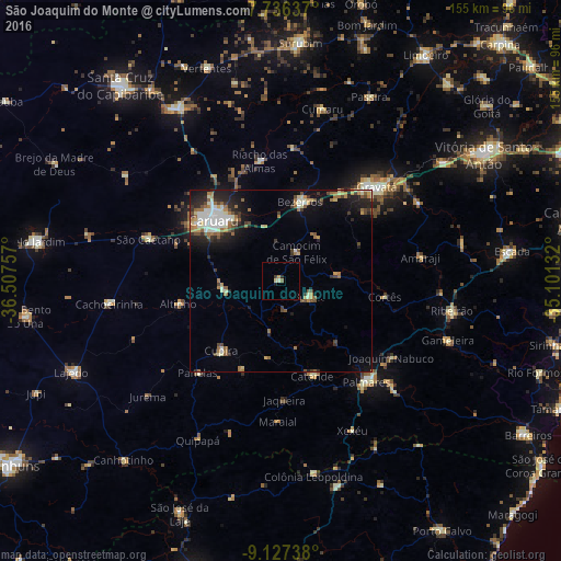
Analysis of São Joaquim do Monte night lights 2016
Square area 10x10 km:
 0%
0%90-99
0.62%80-89
1.03%70-79
0.83%60-69
0.62%50-59
0.21%40-49
0.21%30-39
0.62%20-29
0.83%10-19
0.83%0-9
94.21%Square area 50x50 km:
1.04%90-99
1.79%80-89
0.72%70-79
0.78%60-69
1.73%50-59
1.2%40-49
1.14%30-39
1.15%20-29
2.38%10-19
4.61%0-9
83.45%Clear (daylight) street map image can be seen on geolist.org.
Map coordinates:
7° 44' 10.9" South, 36° 30' 27.3" West
8° 25' 57" South, 35° 48' 16" West
9° 7' 38.6" South, 35° 6' 4.8" West
Some cities around São Joaquim do Monte sort by population:
• Caruaru
25.1 km =15.6 mi,  311°
311°
• Bezerros
22.2 km =13.8 mi,  2°
2°
• Catende
27.8 km =17.3 mi,  159°
159°
• Cupira
26 km =16.2 mi,  218°
218°
• Agrestina
15.7 km =9.8 mi,  259°
259°
• Camocim de São Félix
9.5 km =5.9 mi,  29°
29°
• Guabiraba
15.3 km =9.5 mi,  83°
83°
• Bonito
9.3 km =5.8 mi,  116°
116°
3388567 (p: 13,520)
Sources (retrieved 2019-11-25):
» Earth at Night: Flat Maps 2012, 2016