Guabiraba night lights from space
Night Light of Guabiraba (Pernambuco) from space (Brazil) Src. Average luminocity for 10x10km area is 2.6715% and for 50x50km: 6.0471%.
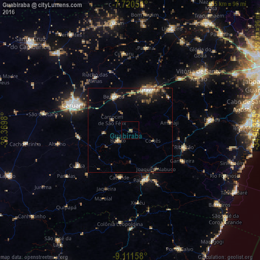
Analysis of Guabiraba night lights 2016
Square area 10x10 km:
 0%
0%90-99
0%80-89
0%70-79
0.83%60-69
1.45%50-59
0.21%40-49
0.21%30-39
1.03%20-29
0.41%10-19
0%0-9
95.87%Square area 50x50 km:
0.25%90-99
0.84%80-89
0.76%70-79
0.67%60-69
1.16%50-59
1.04%40-49
1.09%30-39
1.1%20-29
1.3%10-19
3.28%0-9
88.5%Clear (daylight) street map image can be seen on geolist.org.
Map coordinates:
7° 43' 13.8" South, 36° 22' 11.3" West
8° 25' 0" South, 35° 40' 0" West
9° 6' 41.7" South, 34° 57' 48.8" West
Some cities around Guabiraba sort by population:
• Gravatá
26.5 km =16.5 mi,  25°
25°
• Bezerros
24.9 km =15.5 mi,  324°
324°
• Catende
28.3 km =17.6 mi,  191°
191°
• Amaraji
23.9 km =14.9 mi,  80°
80°
• São Joaquim do Monte
15.3 km =9.5 mi,  263°
263°
• Camocim de São Félix
12.3 km =7.6 mi,  301°
301°
• Joaquim Nabuco
27.4 km =17 mi,  147°
147°
• Bonito
9.1 km =5.7 mi,  228°
228°
3398622 (p: 9,285)
Sources (retrieved 2019-11-25):
» Earth at Night: Flat Maps 2012, 2016