Bonito night lights from space
Night Light of Bonito (Pernambuco) from space (Brazil) Src. Average luminocity for 10x10km area is 8.969% and for 50x50km: 5.7501%.
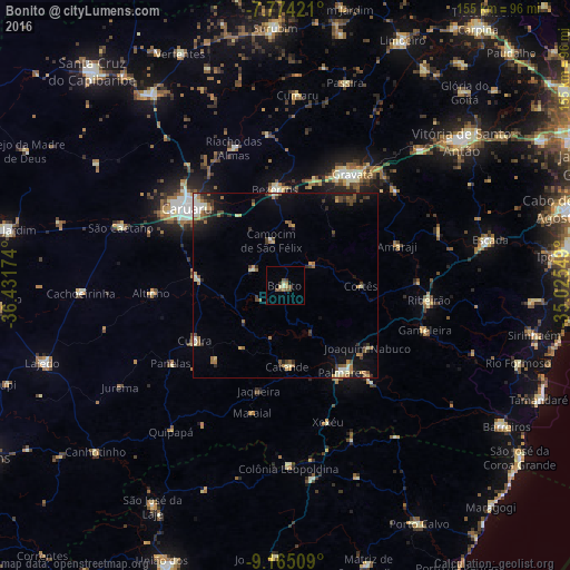
Analysis of Bonito night lights 2016
Square area 10x10 km:
 0%
0%90-99
1.24%80-89
1.24%70-79
0.83%60-69
1.65%50-59
3.72%40-49
1.24%30-39
1.65%20-29
0%10-19
0.41%0-9
88.02%Square area 50x50 km:
0.3%90-99
0.98%80-89
0.48%70-79
0.43%60-69
1.42%50-59
0.88%40-49
0.94%30-39
1.01%20-29
1.09%10-19
3.09%0-9
89.36%Clear (daylight) street map image can be seen on geolist.org.
Map coordinates:
7° 46' 27.2" South, 36° 25' 54.3" West
8° 28' 13" South, 35° 43' 43" West
9° 9' 54.3" South, 35° 1' 31.8" West
Some cities around Bonito sort by population:
• Bezerros
27.4 km =17 mi,  344°
344°
• Palmares
28.1 km =17.5 mi,  147°
147°
• Catende
21.9 km =13.6 mi,  176°
176°
• Agrestina
23.8 km =14.8 mi,  273°
273°
• São Joaquim do Monte
9.3 km =5.8 mi,  296°
296°
• Camocim de São Félix
12.9 km =8 mi, 343°
• Joaquim Nabuco
27.5 km =17.1 mi,  128°
128°
• Guabiraba
9.1 km =5.7 mi,  48°
48°
3405172 (p: 8,865)
Sources (retrieved 2019-11-25):
» Earth at Night: Flat Maps 2012, 2016