Agrestina night lights from space
Night Light of Agrestina (Pernambuco) from space (Brazil) Src. Average luminocity for 10x10km area is 6.4669% and for 50x50km: 8.0888%.
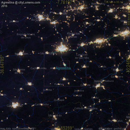
Analysis of Agrestina night lights 2016
Square area 10x10 km:
 0%
0%90-99
1.65%80-89
0.83%70-79
0.41%60-69
2.89%50-59
0.83%40-49
0.83%30-39
0%20-29
0.83%10-19
0%0-9
91.74%Square area 50x50 km:
1.01%90-99
1.81%80-89
0.52%70-79
0.74%60-69
1.58%50-59
1.25%40-49
1.05%30-39
1.12%20-29
1.78%10-19
3.38%0-9
85.75%Clear (daylight) street map image can be seen on geolist.org.
Map coordinates:
7° 45' 43.1" South, 36° 38' 52.3" West
8° 27' 29" South, 35° 56' 41" West
9° 9' 10.4" South, 35° 14' 29.8" West
Some cities around Agrestina sort by population:
• Caruaru
19.7 km =12.2 mi,  349°
349°
• Bezerros
29.8 km =18.5 mi,  33°
33°
• Cupira
17.6 km =10.9 mi,  181°
181°
• São Joaquim do Monte
15.7 km =9.8 mi,  79°
79°
• Altinho
13.1 km =8.1 mi,  254°
254°
• Camocim de São Félix
22.9 km =14.2 mi,  61°
61°
• Guabiraba
30.9 km =19.2 mi, 81°
• Bonito
23.8 km =14.8 mi,  93°
93°
3408251 (p: 14,452)
Sources (retrieved 2019-11-25):
» Earth at Night: Flat Maps 2012, 2016