Cupira night lights from space
Night Light of Cupira (Pernambuco) from space (Brazil) Src. Average luminocity for 10x10km area is 10.1921% and for 50x50km: 2.3051%.
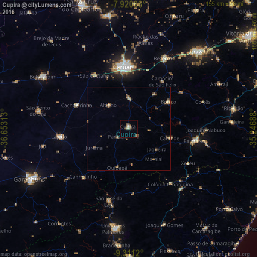
Analysis of Cupira night lights 2016
Square area 10x10 km:
 0.83%
0.83%90-99
1.65%80-89
0.83%70-79
0%60-69
4.13%50-59
1.65%40-49
2.48%30-39
0.83%20-29
0%10-19
0%0-9
87.6%Square area 50x50 km:
0.03%90-99
0.27%80-89
0.29%70-79
0.24%60-69
0.82%50-59
0.45%40-49
0.33%30-39
0.38%20-29
0.35%10-19
0.19%0-9
96.63%Clear (daylight) street map image can be seen on geolist.org.
Map coordinates:
7° 55' 15.1" South, 36° 39' 11.3" West
8° 37' 0" South, 35° 57' 0" West
9° 18' 40.3" South, 35° 14' 48.8" West
Some cities around Cupira sort by population:
• Catende
26.2 km =16.3 mi,  102°
102°
• Agrestina
17.6 km =10.9 mi,  1°
1°
• Maraial
24.1 km =15 mi,  139°
139°
• São Joaquim do Monte
26 km =16.2 mi,  38°
38°
• Cachoeirinha
34.3 km =21.3 mi,  294°
294°
• Altinho
18.5 km =11.5 mi,  319°
319°
• Quipapá
24.4 km =15.2 mi,  196°
196°
• Bonito
29.3 km =18.2 mi,  56°
56°
3401340 (p: 19,096)
Sources (retrieved 2019-11-25):
» Earth at Night: Flat Maps 2012, 2016