São João Batista night lights from space
Night Light of São João Batista (Santa Catarina) from space (Brazil) Src. Average luminocity for 10x10km area is 21.7273% and for 50x50km: 12.4268%.
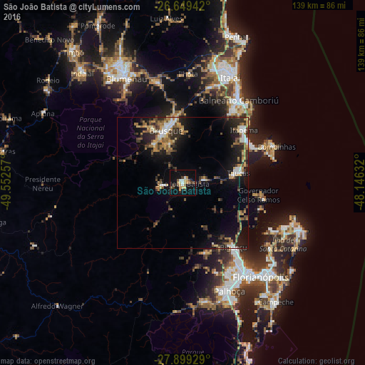
Analysis of São João Batista night lights 2016
Square area 10x10 km:
 1.52%
1.52%90-99
2.27%80-89
3.22%70-79
3.41%60-69
3.22%50-59
2.46%40-49
3.6%30-39
3.03%20-29
1.52%10-19
24.24%0-9
51.52%Square area 50x50 km:
1.17%90-99
1.53%80-89
1.37%70-79
1.5%60-69
2.2%50-59
2.05%40-49
1.67%30-39
2.47%20-29
3.98%10-19
8.77%0-9
73.29%Clear (daylight) street map image can be seen on geolist.org.
Map coordinates:
26° 38' 57.9" South, 49° 33' 9.3" West
27° 16' 34" South, 48° 50' 58" West
27° 53' 57.4" South, 48° 8' 46.8" West
Some cities around São João Batista sort by population:
• Brusque
20.8 km =12.9 mi,  342°
342°
• Biguaçu
30.9 km =19.2 mi,  141°
141°
• Balneário Camboriú
38.2 km =23.7 mi,  33°
33°
• Itapema
31.3 km =19.4 mi,  48°
48°
• Gaspar
39.8 km =24.7 mi, 344°
• Tijucas
21.7 km =13.5 mi,  79°
79°
• Campinas
42.7 km =26.5 mi,  145°
145°
• Porto Belo
32.1 km =19.9 mi,  65°
65°
3448906 (p: 14,538)
Sources (retrieved 2019-11-25):
» Earth at Night: Flat Maps 2012, 2016