Rio Casca night lights from space
Night Light of Rio Casca (Minas Gerais) from space (Brazil) Src. Average luminocity for 10x10km area is 3.4583% and for 50x50km: 2.2377%.
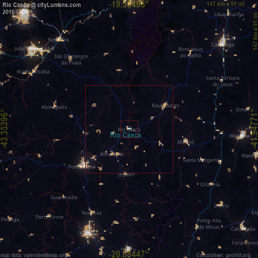
Analysis of Rio Casca night lights 2016
Square area 10x10 km:
 0%
0%90-99
0.2%80-89
0.6%70-79
1.59%60-69
0.79%50-59
0%40-49
0%30-39
0.79%20-29
0%10-19
1.79%0-9
94.25%Square area 50x50 km:
0.02%90-99
0.04%80-89
0.17%70-79
0.68%60-69
0.56%50-59
0.28%40-49
0.62%30-39
0.43%20-29
0.29%10-19
0.87%0-9
96.03%Clear (daylight) street map image can be seen on geolist.org.
Map coordinates:
19° 33' 53.9" South, 43° 21' 14.3" West
20° 13' 34" South, 42° 39' 3" West
20° 53' 4.1" South, 41° 56' 51.8" West
Some cities around Rio Casca sort by population:
• Viçosa
63.4 km =39.4 mi,  202°
202°
• Manhuaçu
64.5 km =40.1 mi,  93°
93°
• Ponte Nova
34.2 km =21.3 mi,  231°
231°
• Matipó
32.9 km =20.4 mi,  101°
101°
• Bom Jesus do Galho
56.3 km =35 mi,  38°
38°
• Alvinópolis
43.6 km =27.1 mi,  287°
287°
• Rio Piracicaba
63.9 km =39.7 mi,  301°
301°
• São Domingos do Prata
52.1 km =32.4 mi,  320°
320°
3451236 (p: 11,769)
Sources (retrieved 2019-11-25):
» Earth at Night: Flat Maps 2012, 2016