Bom Jesus do Galho night lights from space
Night Light of Bom Jesus do Galho (Minas Gerais) from space (Brazil) Src. Average luminocity for 10x10km area is 3.7792% and for 50x50km: 2.1643%.
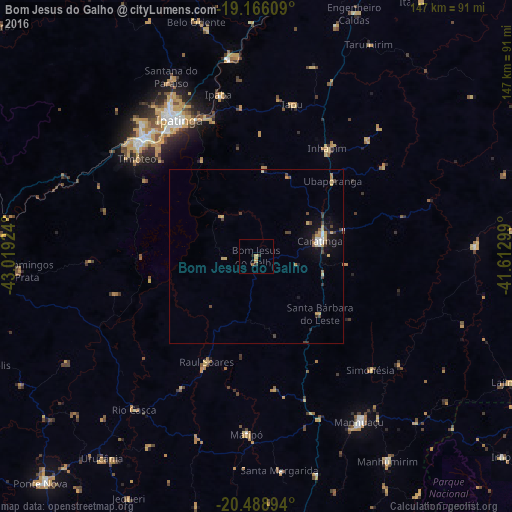
Analysis of Bom Jesus do Galho night lights 2016
Square area 10x10 km:
 0%
0%90-99
0%80-89
0%70-79
2.6%60-69
0.65%50-59
0.22%40-49
0.87%30-39
0%20-29
1.73%10-19
0.43%0-9
93.51%Square area 50x50 km:
0.15%90-99
0.16%80-89
0.45%70-79
0.45%60-69
0.18%50-59
0.11%40-49
0.61%30-39
0.3%20-29
0.3%10-19
1.4%0-9
95.89%Clear (daylight) street map image can be seen on geolist.org.
Map coordinates:
19° 9' 57.9" South, 43° 1' 9.3" West
19° 49' 44" South, 42° 18' 58" West
20° 29' 20.2" South, 41° 36' 46.8" West
Some cities around Bom Jesus do Galho sort by population:
• Ipatinga
46.3 km =28.8 mi,  330°
330°
• Coronel Fabriciano
47.6 km =29.6 mi,  316°
316°
• Timóteo
44.5 km =27.7 mi,  308°
308°
• Caratinga
19 km =11.8 mi,  76°
76°
• Manhuaçu
56.1 km =34.9 mi,  148°
148°
• Ipaba
47.4 km =29.5 mi,  346°
346°
• Inhapim
37.3 km =23.2 mi,  33°
33°
• Matipó
50.7 km =31.5 mi,  182°
182°
3469426 (p: 12,475)
Sources (retrieved 2019-11-25):
» Earth at Night: Flat Maps 2012, 2016