São Domingos do Prata night lights from space
Night Light of São Domingos do Prata (Minas Gerais) from space (Brazil) Src. Average luminocity for 10x10km area is 3.6926% and for 50x50km: 3.9881%.
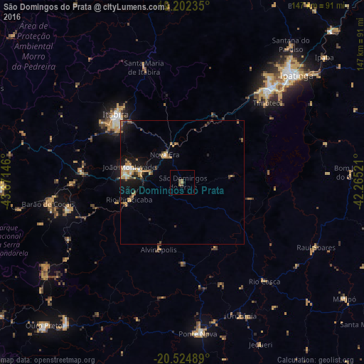
Analysis of São Domingos do Prata night lights 2016
Square area 10x10 km:
 0%
0%90-99
0%80-89
0%70-79
0.87%60-69
1.52%50-59
0.65%40-49
2.16%30-39
0%20-29
0.87%10-19
0.87%0-9
93.07%Square area 50x50 km:
0.3%90-99
0.29%80-89
0.41%70-79
1.21%60-69
0.63%50-59
0.32%40-49
0.79%30-39
0.38%20-29
0.74%10-19
2.95%0-9
91.99%Clear (daylight) street map image can be seen on geolist.org.
Map coordinates:
19° 12' 8.5" South, 43° 40' 17.3" West
19° 51' 54" South, 42° 58' 6" West
20° 31' 29.6" South, 42° 15' 54.8" West
Some cities around São Domingos do Prata sort by population:
• Coronel Fabriciano
52.4 km =32.6 mi,  42°
42°
• Itabira
38.5 km =23.9 mi,  315°
315°
• Timóteo
45.9 km =28.5 mi,  46°
46°
• João Monlevade
22.3 km =13.9 mi,  285°
285°
• Nova Era
14.7 km =9.1 mi,  330°
330°
• Alvinópolis
28.2 km =17.5 mi,  197°
197°
• Rio Casca
52.1 km =32.4 mi,  140°
140°
• Rio Piracicaba
22.7 km =14.1 mi,  251°
251°
3449219 (p: 9,466)
Sources (retrieved 2019-11-25):
» Earth at Night: Flat Maps 2012, 2016