Ribeirópolis night lights from space
Night Light of Ribeirópolis (Sergipe) from space (Brazil) Src. Average luminocity for 10x10km area is 45.1736% and for 50x50km: 20.9478%.
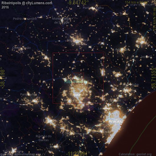
Analysis of Ribeirópolis night lights 2016
Square area 10x10 km:
 3.93%
3.93%90-99
6.82%80-89
6.61%70-79
5.17%60-69
9.71%50-59
12.81%40-49
4.75%30-39
10.74%20-29
11.78%10-19
22.73%0-9
4.96%Square area 50x50 km:
1.58%90-99
3.11%80-89
2.48%70-79
3.17%60-69
4.54%50-59
4.37%40-49
3.11%30-39
3.61%20-29
5.76%10-19
10.31%0-9
57.95%Clear (daylight) street map image can be seen on geolist.org.
Map coordinates:
9° 50' 50.7" South, 38° 7' 11.3" West
10° 32' 22" South, 37° 25' 0" West
11° 13' 47.7" South, 36° 42' 48.8" West
Some cities around Ribeirópolis sort by population:
• Itabaiana
16.2 km =10.1 mi,  183°
183°
• Nossa Senhora da Glória
35.7 km =22.2 mi,  359°
359°
• Nossa Senhora das Dores
25 km =15.5 mi,  77°
77°
• Carira
36.9 km =22.9 mi,  302°
302°
• Campo do Brito
23.1 km =14.4 mi,  201°
201°
• Areia Branca
26.7 km =16.6 mi,  155°
155°
• Frei Paulo
12.9 km =8 mi,  265°
265°
• Malhador
18 km =11.2 mi,  137°
137°
3451305 (p: 11,214)
Sources (retrieved 2019-11-25):
» Earth at Night: Flat Maps 2012, 2016