Nossa Senhora das Dores night lights from space
Night Light of Nossa Senhora das Dores (Sergipe) from space (Brazil) Src. Average luminocity for 10x10km area is 29.9731% and for 50x50km: 19.2566%.
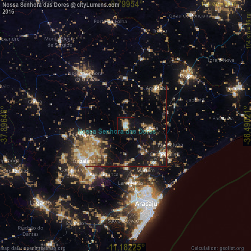
Analysis of Nossa Senhora das Dores night lights 2016
Square area 10x10 km:
 3.1%
3.1%90-99
6.61%80-89
1.03%70-79
5.79%60-69
3.72%50-59
6.82%40-49
1.03%30-39
2.48%20-29
2.69%10-19
45.04%0-9
21.69%Square area 50x50 km:
1.25%90-99
2.4%80-89
1.93%70-79
2.71%60-69
3.35%50-59
4.61%40-49
3.06%30-39
2.88%20-29
4.43%10-19
16.26%0-9
57.12%Clear (daylight) street map image can be seen on geolist.org.
Map coordinates:
9° 47' 58.3" South, 37° 53' 47.3" West
10° 29' 30" South, 37° 11' 36" West
11° 10' 56.1" South, 36° 29' 24.8" West
Some cities around Nossa Senhora das Dores sort by population:
• Itabaiana
33.2 km =20.6 mi,  229°
229°
• Capela
15.4 km =9.6 mi,  94°
94°
• Maruim
29.9 km =18.6 mi,  155°
155°
• Ribeirópolis
25 km =15.5 mi,  257°
257°
• Aquidabã
30.2 km =18.8 mi,  39°
39°
• Japaratuba
29.9 km =18.6 mi,  112°
112°
• Areia Branca
32.5 km =20.2 mi,  204°
204°
• Malhador
22.1 km =13.7 mi,  213°
213°
3456234 (p: 14,550)
Sources (retrieved 2019-11-25):
» Earth at Night: Flat Maps 2012, 2016