Malhador night lights from space
Night Light of Malhador (Sergipe) from space (Brazil) Src. Average luminocity for 10x10km area is 37.7397% and for 50x50km: 30.246%.
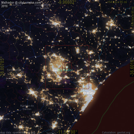
Analysis of Malhador night lights 2016
Square area 10x10 km:
 1.03%
1.03%90-99
3.72%80-89
4.55%70-79
5.58%60-69
11.78%50-59
8.26%40-49
9.09%30-39
6.61%20-29
9.92%10-19
27.07%0-9
12.4%Square area 50x50 km:
2.63%90-99
4.89%80-89
3.12%70-79
4.35%60-69
5.82%50-59
6.32%40-49
4.6%30-39
5.22%20-29
8.65%10-19
18.81%0-9
35.59%Clear (daylight) street map image can be seen on geolist.org.
Map coordinates:
9° 57' 57.7" South, 38° 0' 28.3" West
10° 39' 28" South, 37° 18' 17" West
11° 20' 52.7" South, 36° 36' 5.8" West
Some cities around Malhador sort by population:
• Itabaiana
13.5 km =8.4 mi,  257°
257°
• Laranjeiras
22.1 km =13.7 mi,  138°
138°
• Nossa Senhora das Dores
22.1 km =13.7 mi,  33°
33°
• Maruim
25.9 km =16.1 mi,  109°
109°
• Ribeirópolis
18 km =11.2 mi,  317°
317°
• Campo do Brito
22.3 km =13.9 mi,  247°
247°
• Areia Branca
11.2 km =7 mi,  185°
185°
• Frei Paulo
27.8 km =17.3 mi,  295°
295°
3458093 (p: 5,574)
Sources (retrieved 2019-11-25):
» Earth at Night: Flat Maps 2012, 2016