Campo do Brito night lights from space
Night Light of Campo do Brito (Sergipe) from space (Brazil) Src. Average luminocity for 10x10km area is 45.9174% and for 50x50km: 26.3384%.
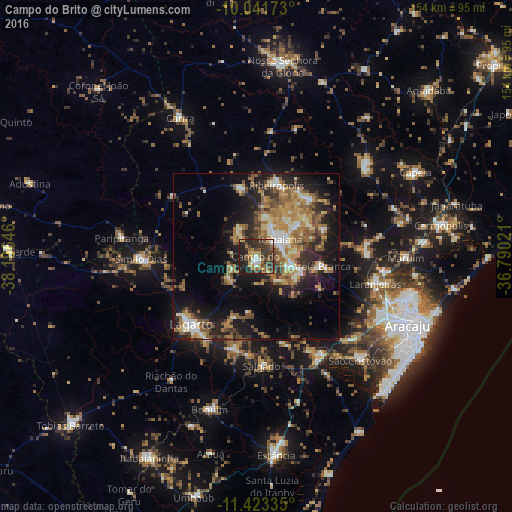
Analysis of Campo do Brito night lights 2016
Square area 10x10 km:
 3.72%
3.72%90-99
4.55%80-89
2.48%70-79
7.64%60-69
9.3%50-59
9.92%40-49
11.57%30-39
19.83%20-29
22.93%10-19
8.06%0-9
0%Square area 50x50 km:
1.93%90-99
3.94%80-89
2.92%70-79
4%60-69
5.7%50-59
5.65%40-49
3.86%30-39
4.39%20-29
8.1%10-19
14.44%0-9
45.08%Clear (daylight) street map image can be seen on geolist.org.
Map coordinates:
10° 2' 30.2" South, 38° 11' 47.3" West
10° 43' 60" South, 37° 29' 36" West
11° 25' 24.1" South, 36° 47' 24.8" West
Some cities around Campo do Brito sort by population:
• Itabaiana
9.2 km =5.7 mi,  54°
54°
• Lagarto
26.7 km =16.6 mi,  219°
219°
• Simão Dias
34.7 km =21.6 mi,  269°
269°
• Ribeirópolis
23.1 km =14.4 mi,  21°
21°
• Areia Branca
19.6 km =12.2 mi,  97°
97°
• Frei Paulo
20.9 km =13 mi,  347°
347°
• Malhador
22.3 km =13.9 mi,  67°
67°
• Salgado
33.3 km =20.7 mi,  176°
176°
3467780 (p: 8,011)
Sources (retrieved 2019-11-25):
» Earth at Night: Flat Maps 2012, 2016