Nossa Senhora da Glória night lights from space
Night Light of Nossa Senhora da Glória (Sergipe) from space (Brazil) Src. Average luminocity for 10x10km area is 46.8554% and for 50x50km: 6.9861%.
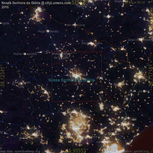
Analysis of Nossa Senhora da Glória night lights 2016
Square area 10x10 km:
 5.99%
5.99%90-99
8.88%80-89
4.55%70-79
3.72%60-69
12.4%50-59
11.57%40-49
5.17%30-39
7.64%20-29
11.16%10-19
27.07%0-9
1.86%Square area 50x50 km:
0.35%90-99
0.66%80-89
0.52%70-79
0.51%60-69
0.84%50-59
1.66%40-49
1.73%30-39
1.84%20-29
2.28%10-19
4.06%0-9
85.55%Clear (daylight) street map image can be seen on geolist.org.
Map coordinates:
9° 31' 32.2" South, 38° 7' 24.3" West
10° 13' 6" South, 37° 25' 13" West
10° 54' 34.3" South, 36° 43' 1.8" West
Some cities around Nossa Senhora da Glória sort by population:
• Capela
51.2 km =31.8 mi,  128°
128°
• Ribeirópolis
35.7 km =22.2 mi,  179°
179°
• Aquidabã
44.5 km =27.7 mi,  99°
99°
• Carira
34.6 km =21.5 mi,  242°
242°
• Porto da Folha
36.9 km =22.9 mi,  24°
24°
• Frei Paulo
38.9 km =24.2 mi,  198°
198°
• Monte Alegre de Sergipe
26.3 km =16.3 mi,  323°
323°
• Malhador
50.5 km =31.4 mi,  165°
165°
3456240 (p: 18,612)
Sources (retrieved 2019-11-25):
» Earth at Night: Flat Maps 2012, 2016